IMAGES TAKEN NEAR TO
South Drive, BANSTEAD, SM7 3BH
Introduction
This page details the photographs taken nearby to South Drive, SM7 3BH by members of the Geograph project.
The Geograph project started in 2005 with the aim of publishing, organising and preserving representative images for every square kilometre of Great Britain, Ireland and the Isle of Man.

There are currently over 7.5m images from over14,400 individuals and you can help contribute to the project by visiting https://www.geograph.org.uk
Image Map (Loading...)


Getting Data...Please wait
Leaflet Map data © OpenStreetMap
Images are licensed for reuse under creativecommons.org/licenses/by-sa/2.0
Notes
- Clicking on the map will re-center to the selected point.
- The higher the marker number, the further away the image location is from the centre of the postcode.
Image Listing (21 Images Found)
Images are licensed for reuse under creativecommons.org/licenses/by-sa/2.0
Image
Details
Distance
1
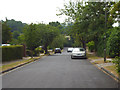
Banstead: South Drive
Spacious cul-de-sac of upmarket properties
Image: © Dr Neil Clifton
Taken: 21 Jul 2013
0.02 miles
2
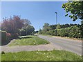
A2022 near Woodmansterne
The housing in the area is in a small unnamed hamlet.
Image: © James Emmans
Taken: 6 May 2020
0.09 miles
4
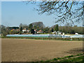
Nursery by The Oaks Farm
Farm produce is also sold.
Image: © Robin Webster
Taken: 30 Mar 2012
0.14 miles
5
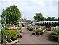
Plants For Sale
Part of a garden centre near Woodmansterne.
Image: © Des Blenkinsopp
Taken: 23 May 2012
0.14 miles
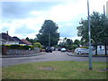
6
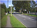
Croydon Lane, Banstead (A2022)
Looking east, by Fairlawn Grove
Image: © Noel Foster
Taken: 13 Sep 2005
0.15 miles
7
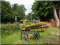
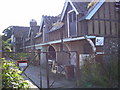
Farm Shop Barrow
This old costermonger's barrow is outside a farm shop and garden centre.
Image: © Des Blenkinsopp
Taken: 23 May 2012
0.15 miles
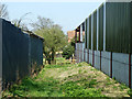
8
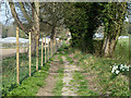
Footpath towards Croydon Lane
It emerges beside Oaks Farm.
Image: © Robin Webster
Taken: 30 Mar 2012
0.18 miles
9
Oaks Farm, Croydon Lane, Banstead (A2022)
Image: © Noel Foster
Taken: 13 Sep 2005
0.19 miles
10
Footpath towards Croydon Lane
Oaks Farm on the right, The Oak Tree Nurseries on the left.
Image: © Robin Webster
Taken: 30 Mar 2012
0.19 miles