IMAGES TAKEN NEAR TO
Daniel Way, Lambert Road, BANSTEAD, SM7 2QW
Introduction
This page details the photographs taken nearby to Daniel Way, Lambert Road, SM7 2QW by members of the Geograph project.
The Geograph project started in 2005 with the aim of publishing, organising and preserving representative images for every square kilometre of Great Britain, Ireland and the Isle of Man.

There are currently over 7.5m images from over14,400 individuals and you can help contribute to the project by visiting https://www.geograph.org.uk
Image Map
Images are licensed for reuse under creativecommons.org/licenses/by-sa/2.0
Notes
- Clicking on the map will re-center to the selected point.
- The higher the marker number, the further away the image location is from the centre of the postcode.
Image Listing (23 Images Found)
Images are licensed for reuse under creativecommons.org/licenses/by-sa/2.0
Image
Details
Distance
1
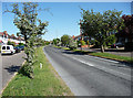
Winkworth Road, Banstead
Houses are set back with access roads, the space between being pleasantly planted with trees and shrubs.
Image: © Stephen Richards
Taken: Unknown
0.08 miles
3
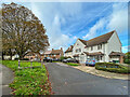
Barnfield
c.1950s cul de sac off Sutton Lane.
Image: © Ian Capper
Taken: 7 Oct 2022
0.19 miles
5
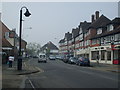
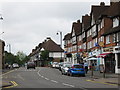
Banstead High Street
Banstead shops.in the high street.
Image: © Henry Spooner
Taken: 22 Apr 2009
0.22 miles
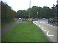
7

Roundabout on Sutton Lane, Banstead
Looking towards Croydon Lane
Image: © David Howard
Taken: 14 Jan 2013
0.22 miles
8
Roundabout, Banstead.
Where Sutton Lane (B2218) crosses Winkworth Road (this side) / Croydon Lane (other side) the A2022
Image: © Noel Foster
Taken: 14 Sep 2005
0.22 miles
9
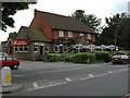
The Woolpack
This pub was built after the previous one was destroyed during World War Two.
Image: © John Barrett
Taken: 16 May 2005
0.23 miles
10
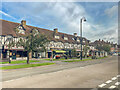
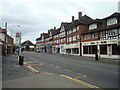
High Street
1920/30s mock Tudor shopping parade in Banstead High Street, first marked on the 1935 25 inch map.
Image: © Ian Capper
Taken: 7 Oct 2022
0.23 miles