IMAGES TAKEN NEAR TO
Follyfield Road, BANSTEAD, SM7 2LA
Introduction
This page details the photographs taken nearby to Follyfield Road, SM7 2LA by members of the Geograph project.
The Geograph project started in 2005 with the aim of publishing, organising and preserving representative images for every square kilometre of Great Britain, Ireland and the Isle of Man.

There are currently over 7.5m images from over14,400 individuals and you can help contribute to the project by visiting https://www.geograph.org.uk
Image Map (Loading...)


Getting Data...Please wait
Leaflet Map data © OpenStreetMap
Images are licensed for reuse under creativecommons.org/licenses/by-sa/2.0
Notes
- Clicking on the map will re-center to the selected point.
- The higher the marker number, the further away the image location is from the centre of the postcode.
Image Listing (5 Images Found)
Images are licensed for reuse under creativecommons.org/licenses/by-sa/2.0
Image
Details
Distance
1
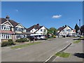
Commonfield Road - Banstead
Close to the footpath to Banstead Commons.
Image: © James Emmans
Taken: 6 May 2020
0.17 miles
2
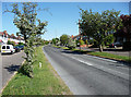
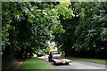
Winkworth Road, Banstead
Houses are set back with access roads, the space between being pleasantly planted with trees and shrubs.
Image: © Stephen Richards
Taken: Unknown
0.19 miles
3
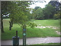
London Loop across the Banstead Downs golf course
Image: © Noel Foster
Taken: 14 Sep 2005
0.19 miles
4
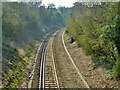
View south from bridge NFE 1245
The branch line from Sutton to Epsom Downs, originally all double line, but the southern part is now single line.
Image: © Robin Webster
Taken: 30 Mar 2012
0.20 miles
5
Winkworth Road
Located on the northern edge of Banstead.
Image: © Peter Trimming
Taken: 29 Jun 2017
0.23 miles