IMAGES TAKEN NEAR TO
Elizabeth Drive, BANSTEAD, SM7 2FD
Introduction
This page details the photographs taken nearby to Elizabeth Drive, SM7 2FD by members of the Geograph project.
The Geograph project started in 2005 with the aim of publishing, organising and preserving representative images for every square kilometre of Great Britain, Ireland and the Isle of Man.

There are currently over 7.5m images from over14,400 individuals and you can help contribute to the project by visiting https://www.geograph.org.uk
Image Map
Images are licensed for reuse under creativecommons.org/licenses/by-sa/2.0
Notes
- Clicking on the map will re-center to the selected point.
- The higher the marker number, the further away the image location is from the centre of the postcode.
Image Listing (3 Images Found)
Images are licensed for reuse under creativecommons.org/licenses/by-sa/2.0
Image
Details
Distance
1
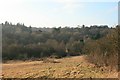
Park Downs
Park Downs is common land and a site of special scientific interest because of its downland flora, although the battle against scrub encroachment is ceaseless. The Downs are managed by the Banstead Commons Conservators (http://www.bansteadcommonsconservators.org.uk ), but unusually, the rights of common (to graze animals on Park Downs) belong to the National Trust. In the distance, rising above Banstead Wood, is the water tower of the former Queen Elizabeth Hospital, now converted to a residential estate.
Image: © Hugh Craddock
Taken: 28 Dec 2008
0.06 miles
2
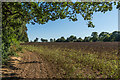
Field edge
Field edge alongside Banstead Wood.
Image: © Ian Capper
Taken: 5 Aug 2018
0.21 miles
3
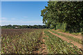
Field edge
Field edge alongside Banstead Wood.
Image: © Ian Capper
Taken: 5 Aug 2018
0.22 miles