IMAGES TAKEN NEAR TO
Ferndale Road, BANSTEAD, SM7 2EX
Introduction
This page details the photographs taken nearby to Ferndale Road, SM7 2EX by members of the Geograph project.
The Geograph project started in 2005 with the aim of publishing, organising and preserving representative images for every square kilometre of Great Britain, Ireland and the Isle of Man.

There are currently over 7.5m images from over14,400 individuals and you can help contribute to the project by visiting https://www.geograph.org.uk
Image Map
Images are licensed for reuse under creativecommons.org/licenses/by-sa/2.0
Notes
- Clicking on the map will re-center to the selected point.
- The higher the marker number, the further away the image location is from the centre of the postcode.
Image Listing (23 Images Found)
Images are licensed for reuse under creativecommons.org/licenses/by-sa/2.0
Image
Details
Distance
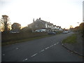
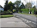
2
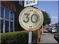
Pre-Worboys speed limit, Ferndale Road Banstead
Image: © David Howard
Taken: 24 May 2009
0.08 miles
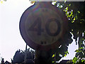
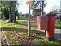
3
Pre-Worboys speed limit, Ferndale Road Banstead
Image: © David Howard
Taken: 24 May 2009
0.08 miles
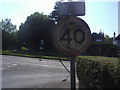
4
Pre-Worboys speed limit, Lyme Regis Road Banstead
Image: © David Howard
Taken: 24 May 2009
0.12 miles
5
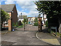
Banstead: The Fieldings, Chipstead Road
The spread of gated communities such as this only adds to the increasing social division of our society.
Image: © Dr Neil Clifton
Taken: 24 Sep 2014
0.14 miles
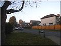
9
Banstead: Garratts Lane, at the end of Garrard Road
Image: © Dr Neil Clifton
Taken: 24 Sep 2014
0.15 miles
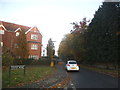
10
View from The Drive, Banstead
This is close to the junction with Brighton Road (A217) and looks towards the road called Woodgavil.
Image: © Marathon
Taken: 4 Nov 2013
0.16 miles