IMAGES TAKEN NEAR TO
Higher Drive, BANSTEAD, SM7 1PW
Introduction
This page details the photographs taken nearby to Higher Drive, SM7 1PW by members of the Geograph project.
The Geograph project started in 2005 with the aim of publishing, organising and preserving representative images for every square kilometre of Great Britain, Ireland and the Isle of Man.

There are currently over 7.5m images from over14,400 individuals and you can help contribute to the project by visiting https://www.geograph.org.uk
Image Map
Images are licensed for reuse under creativecommons.org/licenses/by-sa/2.0
Notes
- Clicking on the map will re-center to the selected point.
- The higher the marker number, the further away the image location is from the centre of the postcode.
Image Listing (6 Images Found)
Images are licensed for reuse under creativecommons.org/licenses/by-sa/2.0
Image
Details
Distance
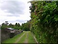
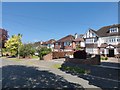
1
Higher Drive
A desirable street of large well kept houses and gardens.
Image: © James Emmans
Taken: 6 May 2020
0.04 miles
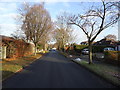
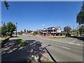
2
Higher Drive, Banstead
An tree-lined enclave of detached houses, separated from the rest of the gridsquare by farmland, despite being only a few miles from Greater London.
Image: © Stephen Richards
Taken: Unknown
0.09 miles
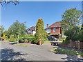
4
Banstead Road
Large modern Tudor style house on corner of Gilham's Avenue.
Image: © James Emmans
Taken: 6 May 2020
0.20 miles