IMAGES TAKEN NEAR TO
Chaucer Close, BANSTEAD, SM7 1PP
Introduction
This page details the photographs taken nearby to Chaucer Close, SM7 1PP by members of the Geograph project.
The Geograph project started in 2005 with the aim of publishing, organising and preserving representative images for every square kilometre of Great Britain, Ireland and the Isle of Man.

There are currently over 7.5m images from over14,400 individuals and you can help contribute to the project by visiting https://www.geograph.org.uk
Image Map
Images are licensed for reuse under creativecommons.org/licenses/by-sa/2.0
Notes
- Clicking on the map will re-center to the selected point.
- The higher the marker number, the further away the image location is from the centre of the postcode.
Image Listing (12 Images Found)
Images are licensed for reuse under creativecommons.org/licenses/by-sa/2.0
Image
Details
Distance
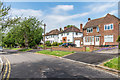
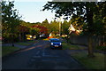
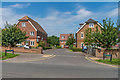
2
Willow Close
2010 development off Warren Road.
Image: © Ian Capper
Taken: 8 Jun 2018
0.06 miles
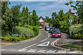
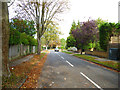
6
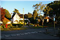
Junction of Nork Way and Warren Road
Note the stink-pipe on the far pavement.
Image: © Christopher Hilton
Taken: 29 May 2015
0.13 miles
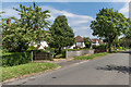
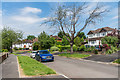
10
Nork: Roundwood Way
Off the north side of Nork Way
Image: © Dr Neil Clifton
Taken: 25 Sep 2014
0.20 miles