IMAGES TAKEN NEAR TO
Pine Place, BANSTEAD, SM7 1LY
Introduction
This page details the photographs taken nearby to Pine Place, SM7 1LY by members of the Geograph project.
The Geograph project started in 2005 with the aim of publishing, organising and preserving representative images for every square kilometre of Great Britain, Ireland and the Isle of Man.

There are currently over 7.5m images from over14,400 individuals and you can help contribute to the project by visiting https://www.geograph.org.uk
Image Map (Loading...)


Getting Data...Please wait
Leaflet Map data © OpenStreetMap
Images are licensed for reuse under creativecommons.org/licenses/by-sa/2.0
Notes
- Clicking on the map will re-center to the selected point.
- The higher the marker number, the further away the image location is from the centre of the postcode.
Image Listing (11 Images Found)
Images are licensed for reuse under creativecommons.org/licenses/by-sa/2.0
Image
Details
Distance
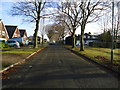
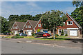
2
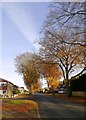
High Beeches, Nork
A suburban street near Drift Bridge - and the name was well chosen. I know nothing of the history of this area, but what is clear is that the beech trees - looking particularly fine in November - are older than the residential development.
Image: © Stefan Czapski
Taken: 17 Nov 2017
0.03 miles
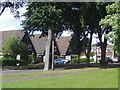
10
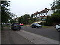
Warren Road, Nork
Opposite St Paul's Church, showing nos.90-98 Warren Road.
Image: © Roger Miller
Taken: 9 Jul 2005
0.19 miles