IMAGES TAKEN NEAR TO
Partridge Mead, BANSTEAD, SM7 1LN
Introduction
This page details the photographs taken nearby to Partridge Mead, SM7 1LN by members of the Geograph project.
The Geograph project started in 2005 with the aim of publishing, organising and preserving representative images for every square kilometre of Great Britain, Ireland and the Isle of Man.

There are currently over 7.5m images from over14,400 individuals and you can help contribute to the project by visiting https://www.geograph.org.uk
Image Map
Images are licensed for reuse under creativecommons.org/licenses/by-sa/2.0
Notes
- Clicking on the map will re-center to the selected point.
- The higher the marker number, the further away the image location is from the centre of the postcode.
Image Listing (5 Images Found)
Images are licensed for reuse under creativecommons.org/licenses/by-sa/2.0
Image
Details
Distance
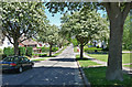
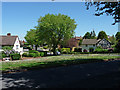
1
Nork: Nork Rise
Off the north side of Nork Way
Image: © Dr Neil Clifton
Taken: 25 Sep 2014
0.19 miles
2
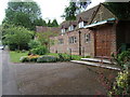
St Paul's Church. Warren Road, Nork, Surrey
Image: © Roger Miller
Taken: 9 Jul 2005
0.21 miles
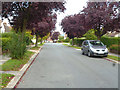
3
Warren Road, Nork
Opposite St Paul's Church, showing nos.90-98 Warren Road.
Image: © Roger Miller
Taken: 9 Jul 2005
0.21 miles
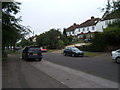
4
Park Wood View, Nork
Taken from Nork Way.
Image: © Stephen Richards
Taken: Unknown
0.21 miles