IMAGES TAKEN NEAR TO
Parkwood View, BANSTEAD, SM7 1JH
Introduction
This page details the photographs taken nearby to Parkwood View, SM7 1JH by members of the Geograph project.
The Geograph project started in 2005 with the aim of publishing, organising and preserving representative images for every square kilometre of Great Britain, Ireland and the Isle of Man.

There are currently over 7.5m images from over14,400 individuals and you can help contribute to the project by visiting https://www.geograph.org.uk
Image Map
Images are licensed for reuse under creativecommons.org/licenses/by-sa/2.0
Notes
- Clicking on the map will re-center to the selected point.
- The higher the marker number, the further away the image location is from the centre of the postcode.
Image Listing (11 Images Found)
Images are licensed for reuse under creativecommons.org/licenses/by-sa/2.0
Image
Details
Distance
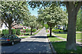
1
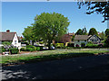
Park Wood View, Nork
Taken from Nork Way.
Image: © Stephen Richards
Taken: Unknown
0.06 miles
2
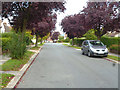
Nork: Nork Rise
Off the north side of Nork Way
Image: © Dr Neil Clifton
Taken: 25 Sep 2014
0.11 miles
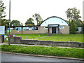
4
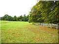
Nork Park, Nork
Elsewhere the park has many of the usual recreational facilities, but this fenced-off area does not seem to be for public consumption. Perhaps it is connected to the farm marked on the OS map.
Image: © Stephen Richards
Taken: Unknown
0.18 miles
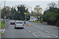
6
A240, Nork
A speed camera and Reigate Road, Nork Way bus stop for route 166 towards Banstead, and school routes 408 and 518.
Image: © Robin Webster
Taken: 1 Apr 2012
0.20 miles
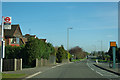
8
A240, Nork
A speed camera is just round the bend at the bottom of the hill.
Image: © Robin Webster
Taken: 1 Apr 2012
0.22 miles
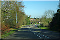
10

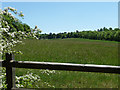
Path alongside Park Wood
Path along the west side of Park Wood. It seems that this hedged path is an amenity path, planted out in the early C20, rather than an older green lane.
Image: © Hugh Craddock
Taken: 23 Apr 2013
0.24 miles