IMAGES TAKEN NEAR TO
Forge Lane, SUTTON, SM3 8SH
Introduction
This page details the photographs taken nearby to Forge Lane, SM3 8SH by members of the Geograph project.
The Geograph project started in 2005 with the aim of publishing, organising and preserving representative images for every square kilometre of Great Britain, Ireland and the Isle of Man.

There are currently over 7.5m images from over14,400 individuals and you can help contribute to the project by visiting https://www.geograph.org.uk
Image Map
Images are licensed for reuse under creativecommons.org/licenses/by-sa/2.0
Notes
- Clicking on the map will re-center to the selected point.
- The higher the marker number, the further away the image location is from the centre of the postcode.
Image Listing (56 Images Found)
Images are licensed for reuse under creativecommons.org/licenses/by-sa/2.0
Image
Details
Distance
2
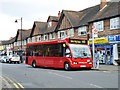
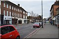
470 bus at Cheam Station bus stop
Quality Line fleet number OP11 on the Epsom - Colliers Wood service.
Image: © Robin Webster
Taken: 10 Apr 2012
0.07 miles
7
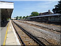
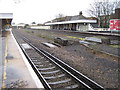
Cheam station
The West Croydon to Epsom railway line was opened in 1847 by the London, Brighton & South Coast Railway and Cheam station also opened then. It did not precipitate the development of the area which remained substantially unchanged for a further 60 years.
Prior to the First World War, the rail bed at Cheam station was widened in preparation for the installation of AC overhead electric services, which would have included the building of an additional central platform island. Due to the outbreak of the First World War, the full planned expansion was cancelled and never completed. This is the explanation for the wide space between the tracks which can be seen in this view from the up platform. Fast lines had been laid but were removed in the 1980s when the South Coast services stopped running through Sutton and Epsom.
The railway at Cheam was best known as the fictional home in the 1950s and 1960s of Tony Hancock who lived at 23 Railway Cuttings, East Cheam. Ray Galton, one of the two scriptwriters, when asked why he chose East Cheam as a location said "To us in those days Cheam was the epitome of upper-class suburbia, the Beverley Hills of South London. And so we thought we'd put him there. But obviously he couldn't really be there as otherwise he'd be quite rich, so we put him in East Cheam, which was not quite Cheam. And there again Railway Cuttings, that made a visual picture of a grimy Victorian terrace."
Image: © Marathon
Taken: 21 Aug 2013
0.11 miles
9
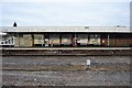
Cheam railway station, Greater London
Opened in 1847 by the London Brighton & South Coast Railway on the line from London Bridge to Epsom.
View east towards Sutton and London.
Image: © Nigel Thompson
Taken: 12 Jan 2011
0.12 miles
10
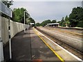
Cheam railway station, Greater London
Opened in 1847 by the London Brighton & South Coast Railway on the line from London Bridge to Epsom.
View west towards Ewell East and Epsom.
Image: © Nigel Thompson
Taken: 26 Jun 2015
0.12 miles