IMAGES TAKEN NEAR TO
Northey Avenue, SUTTON, SM2 7HE
Introduction
This page details the photographs taken nearby to Northey Avenue, SM2 7HE by members of the Geograph project.
The Geograph project started in 2005 with the aim of publishing, organising and preserving representative images for every square kilometre of Great Britain, Ireland and the Isle of Man.

There are currently over 7.5m images from over14,400 individuals and you can help contribute to the project by visiting https://www.geograph.org.uk
Image Map
Images are licensed for reuse under creativecommons.org/licenses/by-sa/2.0
Notes
- Clicking on the map will re-center to the selected point.
- The higher the marker number, the further away the image location is from the centre of the postcode.
Image Listing (7 Images Found)
Images are licensed for reuse under creativecommons.org/licenses/by-sa/2.0
Image
Details
Distance
2
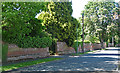
Wall, Cheam
This section of wall on Wilbury Avenue is part of a former hare warren dating from the late C17th; fragments also exist in neighbouring roads. The listed building description records that it, "originally comprised a brick-walled enclosure with egress holes fitted with little trap doors at intervals along the west side ... the walls have been broken down in places to allow space for entrances to C20 houses." Grade II listed.
Image: © Stephen Richards
Taken: Unknown
0.11 miles
3
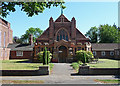
St Andrew Presbyterian Church Hall, Cheam
On Northey Avenue. Of brick and terracotta, by Matley, Brotherton and Mills in 1924-27. Just visible on the left is the newer church of 1931-33 by Maxwell Ayrton.
Image: © Stephen Richards
Taken: Unknown
0.14 miles
4
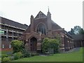
St Andrews United Reformed Church, Cheam
This is St Andrews United Reformed Church, which plays an active role in the surrounding community. The main hall is currently being refurbished, hence the scaffolding. http://www.standrews-cheam.org.uk/
Image: © Hywel Williams
Taken: 19 Sep 2005
0.14 miles
5
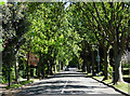
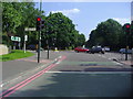
The Avenue, Cheam
Almost all of this gridsquare is made up of wide, tree-lined roads of large, detached C20th houses.
Image: © Stephen Richards
Taken: Unknown
0.16 miles
6
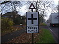
Crossroads sign Belmont Hill
Not long before I took this the original pre-Worboys design was replaced by this modern copy, although the font is not pre-Worboys but Transport font which replaced it. The triangle is still the one which was there before.
Image: © David Howard
Taken: 15 Dec 2008
0.17 miles