IMAGES TAKEN NEAR TO
The Crescent, SUTTON, SM2 7BS
Introduction
This page details the photographs taken nearby to The Crescent, SM2 7BS by members of the Geograph project.
The Geograph project started in 2005 with the aim of publishing, organising and preserving representative images for every square kilometre of Great Britain, Ireland and the Isle of Man.

There are currently over 7.5m images from over14,400 individuals and you can help contribute to the project by visiting https://www.geograph.org.uk
Image Map
Images are licensed for reuse under creativecommons.org/licenses/by-sa/2.0
Notes
- Clicking on the map will re-center to the selected point.
- The higher the marker number, the further away the image location is from the centre of the postcode.
Image Listing (11 Images Found)
Images are licensed for reuse under creativecommons.org/licenses/by-sa/2.0
Image
Details
Distance
2
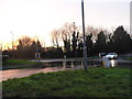
Flooded roundabout on Brighton Road, Belmont
Image: © David Howard
Taken: 14 Jan 2013
0.08 miles
4
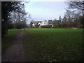
Banstead Downs golf course
The club house is the white building in the background.
Image: © Noel Foster
Taken: 14 Sep 2005
0.11 miles
6
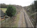
Railway line south of Belmont, towards Banstead
Image: © Nigel Thompson
Taken: 2 Apr 2015
0.17 miles
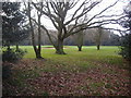
7
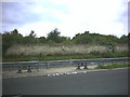
Reservoir on Banstead Downs
The reservoir is behind this wall next to the Brighton Road, Banstead (A217)
Image: © Noel Foster
Taken: 14 Sep 2005
0.18 miles
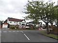
8
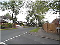
High View at the junction of Wilbury Avenue
Image: © David Howard
Taken: 1 Jun 2014
0.22 miles
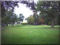
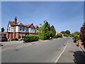
9
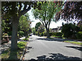
Downs Side, Belmont
Representative of the parts of this gridsquare which are not on a golf course. Wide tree-lined roads with detached C20th houses. Learner-driver heaven too. A nearby private road rather pointedly forbids entry to them.
Image: © Stephen Richards
Taken: Unknown
0.23 miles
10
Wilbury Avenue at the junction of High View
Image: © David Howard
Taken: 1 Jun 2014
0.23 miles