IMAGES TAKEN NEAR TO
Adstock Mews, Church Lane, GERRARDS CROSS, SL9 9RN
Introduction
This page details the photographs taken nearby to Adstock Mews, Church Lane, SL9 9RN by members of the Geograph project.
The Geograph project started in 2005 with the aim of publishing, organising and preserving representative images for every square kilometre of Great Britain, Ireland and the Isle of Man.

There are currently over 7.5m images from over14,400 individuals and you can help contribute to the project by visiting https://www.geograph.org.uk
Image Map
Images are licensed for reuse under creativecommons.org/licenses/by-sa/2.0
Notes
- Clicking on the map will re-center to the selected point.
- The higher the marker number, the further away the image location is from the centre of the postcode.
Image Listing (84 Images Found)
Images are licensed for reuse under creativecommons.org/licenses/by-sa/2.0
Image
Details
Distance
1
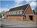
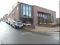
Chalfont St Peter Parish Church Hall
The hall was built in 1972 on the east side of Church Lane and is available for hire.
For geonerds this is a super image. Step to the left and you're in SU land, step to the right and you are in TQ land...!
Image: © Nigel Cox
Taken: 25 Apr 2010
0.04 miles
2
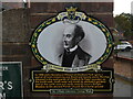
Heritage Plaque in Church Lane, Chalfont St Peter
This plaque is in Church Lane at the entrance to St Peter's Garden. It is one of several on the Celfunde Inheritance Walk and has the image of John Nembhard Hibbert and the following wording:
In 1866 John Nembhard Hibbert of Chalfont Park 'gave a parcel of land containing one Rood
and twenty seven Perches situated in the said parish of Chalfont St Peter bounded on the
south-east, south-west and south by allotment gardens and on the north-east and north-west
by Love's Delight Meadow to the ancient Parish Church for a burial ground'.
Image: © David Hillas
Taken: 26 Aug 2023
0.04 miles
3
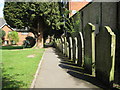
Chalfont St Peter: St Peter's Garden
St Peter's Garden is an old churchyard of Image It is still consecrated ground but, with the permission of the diocese, is now a public open space. The path leads down to Church Lane. I read that there is a list of the burials here on the local parish council website but at the time of submission of this photograph it was not accessible.
Image: © Nigel Cox
Taken: 25 Apr 2010
0.04 miles
4
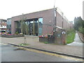
The Hub, Gold Hill Baptist Church, Chalfont St Peter (2)
Located in Church Lane, this church holds services on Sundays and various activities during the week. In addition to being a home for the church, it is also a centre of community activity. Further information on this church can be obtained on Facebook and its website "www.goldhill.org". On the right of the photo is the entrance to St Peter's Garden with a heritage plaque fixed on the wall,
https://www.geograph.org.uk/photo/7579714 refers.
Image: © David Hillas
Taken: 26 Aug 2023
0.04 miles
5
The Hub, Gold Hill Baptist Church, Chalfont St Peter (1)
Situated in Church Lane SL9 9RF, this church opened in September 2021 replacing the one in Gold Hill East, https://www.geograph.org.uk/photo/2065434 refers. It has a large auditorium, a large welcoming foyer, a multi-purpose activity hall, community rooms of various sizes and a terrace looking out to the village at the front.
Image: © David Hillas
Taken: 26 Aug 2023
0.04 miles
6
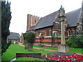
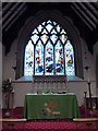
St Peter's Church, Chalfont St Peter
The medieval church was destroyed in 1708 when the tower collapsed onto the nave following flooding. This church dates mostly from the C19.
The earliest recording of the Chalfonts was in 949 as Ceadeles funtan (fountain).
Image: © Bikeboy
Taken: 7 Apr 2014
0.05 miles
7
Chalfont St Peter Parish Church: mid August 2016
Image: © Basher Eyre
Taken: 13 Aug 2016
0.05 miles
8
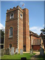
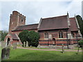
Chalfont St Peter Parish Church
The old church here collapsed in 1708 and the new church, including this west tower, was rebuilt in brick and completed by either 1714 or 1726 depending on which current internet source one uses. The body of the church beyond the tower was substantially modified and extended in Victorian times.
Of interest here are the semi-octagonal stair turret on the right, the roof battlements and the rounded belfry windows. The tower is of red brick with stone quoins.
Image: © Nigel Cox
Taken: 25 Apr 2010
0.05 miles
10
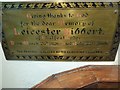
Chalfont St Peter Parish Church: memorial (h)
Image: © Basher Eyre
Taken: 13 Aug 2016
0.06 miles