IMAGES TAKEN NEAR TO
Gravel Hill, GERRARDS CROSS, SL9 9QP
Introduction
This page details the photographs taken nearby to Gravel Hill, SL9 9QP by members of the Geograph project.
The Geograph project started in 2005 with the aim of publishing, organising and preserving representative images for every square kilometre of Great Britain, Ireland and the Isle of Man.

There are currently over 7.5m images from over14,400 individuals and you can help contribute to the project by visiting https://www.geograph.org.uk
Image Map
Images are licensed for reuse under creativecommons.org/licenses/by-sa/2.0
Notes
- Clicking on the map will re-center to the selected point.
- The higher the marker number, the further away the image location is from the centre of the postcode.
Image Listing (83 Images Found)
Images are licensed for reuse under creativecommons.org/licenses/by-sa/2.0
Image
Details
Distance
1
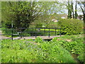
Chalfont St Peter: Vic Wotton Bridge
This footbridge over the River Misbourne is dedicated to the memory of Vic Wotton (1916-2000), a vice-president of the Chiltern Society, who campaigned from the 1970s for the restoration of the River Misbourne from the low flow conditions from which it had suffered in the 20th century. The Misbourne is a classic chalk stream rising in the Chilterns and even without any human activity would be prone to drying up occasionally as ground water levels dropped and rose with rainfall amounts.
The problems initially arose when a mill leat upstream was allowed to deteriorate in the 19th century once the mill was converted to steam power, causing a loss of river water through the leat banks. Then, with the growth of the population of places such as Chalfont St Peter in the 20th century and consequent greater demands for water, abstraction from the ground aquifers was made with a series of boreholes, thus generally reducing the groundwater level.
Finally a sewage treatment works was built, but the unreliability of the water supply meant that there was an inadequate supply of it to dilute the treated sewage and the works was closed. Large holding tanks were then built to contain the sewage until it could be transported for treatment elsewhere. Eventually this operation was by-passed and the tanks demolished. In so doing it would appear that further damage to the river banks occurred and there was a further loss of water through them.
For a comprehensive history of the situation and for the remedial plans please see the Chiltern Society's pamphlet here http://www.chilternsociety.org.uk/dloads/SavingTheMisbourneProposal.pdf
I am pleased to say that on the day the photograph was taken the River Misbourne was flowing with just the right amount of flow that Vic Wotton would have envisaged.
Image: © Nigel Cox
Taken: 25 Apr 2010
0.08 miles
2
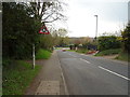
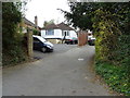
Joiners Lane, Chalfont St Peter
Looking south west towards the roundabout on the A413.
Image: © JThomas
Taken: 13 Apr 2019
0.10 miles
4
Chalfont St. Peter & Chalfont St. Giles Parish Councils
Image: © Bryn Holmes
Taken: 27 Jan 2023
0.11 miles
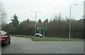
5
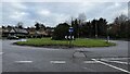
Roundabout leading to Gravel Hill, Joiners Street, High Street and the A413
Image: © Bryn Holmes
Taken: 27 Jan 2023
0.12 miles
6
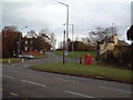
Gravel Hill Junction
Two roads leave the A413 at this point climbing up the valley side to the north and east respectively.
Image: © David Squire
Taken: 5 Dec 2005
0.12 miles
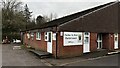
7
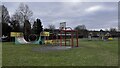
Playground and skate park, Chalfont St Peter
Image: © Bryn Holmes
Taken: 27 Jan 2023
0.12 miles
8
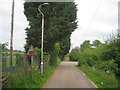
Chalfont St Peter: Mystery road sign
According to the Highway Code the road sign on the left warns of a "Level crossing with barrier or gate ahead", and given its juxtaposition on the page with the sign with a steam engine on it warning of a "Level crossing without barrier or gate ahead" the implication is that we are coming up to a railway here. You would have to walk an awful long distance along the South Bucks Way from here to find the next railway level crossing! Anyway the sign is on the minor road between the River Misbourne on the right and Chalfont St Peter Football Club's ground on the left.
Image: © Nigel Cox
Taken: 24 May 2015
0.12 miles
9
Bungalow on Joiners Lane, Chalfont St Peter
Image: © JThomas
Taken: 13 Apr 2019
0.12 miles
10
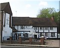
Chalfont St Peter: The Greyhound Inn
Reputedly built in the 17th century for Judge Jeffreys (1645-1689), and later the property of the Whitchurch family, Lords of the Manor of Chalfont St Peter in the 17th and 18th centuries, The Greyhound is at the northern end of the High Street. It is a Grade II Listed Building.
The English Heritage Listed Building reference page, sadly with a spelling mistake needing to be corrected, describes it thus:
"C16 and C18. C16 part is timber-framed with whitewashed brick nogging. Old tile
roof. Two storeys, modern casements. Curved wind braces. C18 part of red
stretchers and grey headers, hipped old tile roof with moulded cornice. Two
storeys, 1st floor band with cyma reversa moulding. Five double-hung sashes with
flat arches. Modern bow window replaces carriageway. West elevation has range of
hipped tiled roofed projections. Reputedly built for Judge Jeffreys."
There is an obvious conflict here. Given that Judge Jeffreys lived only in the 17th century, how could the reputed 16th century inn have been built for him? The answer presumably is that there was an inn here in the 16th century that was substantially rebuilt for him in the 17th century.
Image: © Nigel Cox
Taken: 25 Apr 2010
0.13 miles