IMAGES TAKEN NEAR TO
Grove Hill, GERRARDS CROSS, SL9 9PE
Introduction
This page details the photographs taken nearby to Grove Hill, SL9 9PE by members of the Geograph project.
The Geograph project started in 2005 with the aim of publishing, organising and preserving representative images for every square kilometre of Great Britain, Ireland and the Isle of Man.

There are currently over 7.5m images from over14,400 individuals and you can help contribute to the project by visiting https://www.geograph.org.uk
Image Map
Images are licensed for reuse under creativecommons.org/licenses/by-sa/2.0
Notes
- Clicking on the map will re-center to the selected point.
- The higher the marker number, the further away the image location is from the centre of the postcode.
Image Listing (3 Images Found)
Images are licensed for reuse under creativecommons.org/licenses/by-sa/2.0
Image
Details
Distance
1
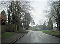
Narcot Lane approaching the College
Also the entrance signs for Chalfont St Peter
Image: © John Firth
Taken: 17 Mar 2012
0.20 miles
2
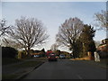
Grove Lane, Chalfont St Peter
Although this looks like a typical suburb as soon as you turn left you're on a single track country road. This is actually right on the edge of open countryside.
Image: © David Howard
Taken: 28 Feb 2013
0.24 miles
3
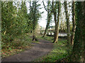
Path at edge of woodland
Narcot Lane is on the right.
Image: © Robin Webster
Taken: 27 Mar 2015
0.25 miles