IMAGES TAKEN NEAR TO
Lovel Road, GERRARDS CROSS, SL9 9NY
Introduction
This page details the photographs taken nearby to Lovel Road, SL9 9NY by members of the Geograph project.
The Geograph project started in 2005 with the aim of publishing, organising and preserving representative images for every square kilometre of Great Britain, Ireland and the Isle of Man.

There are currently over 7.5m images from over14,400 individuals and you can help contribute to the project by visiting https://www.geograph.org.uk
Image Map
Images are licensed for reuse under creativecommons.org/licenses/by-sa/2.0
Notes
- Clicking on the map will re-center to the selected point.
- The higher the marker number, the further away the image location is from the centre of the postcode.
Image Listing (5 Images Found)
Images are licensed for reuse under creativecommons.org/licenses/by-sa/2.0
Image
Details
Distance
1
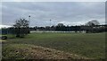
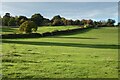
Playing Fields
There are a number of playing fields to the north of Chalfont St Peter. They are all on flat ground that comprise the flood plain of the River Misbourne.
Image: © David Squire
Taken: 5 Dec 2005
0.21 miles
3
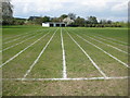
Chalfont St Peter: Athletics track
Possibly utilized by the sack race and the egg and spoon brigade rather than aspiring Olympic athletes, but you never know, and just what prize lurks behind that cricket pavilion door for the winner...?
Image: © Nigel Cox
Taken: 25 Apr 2010
0.22 miles
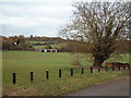
4
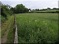
South Bucks Way
South Bucks Way on the edge of Chalfont St Peter
Image: © Shaun Ferguson
Taken: 30 May 2008
0.24 miles