IMAGES TAKEN NEAR TO
Churchfield Road, GERRARDS CROSS, SL9 9EN
Introduction
This page details the photographs taken nearby to Churchfield Road, SL9 9EN by members of the Geograph project.
The Geograph project started in 2005 with the aim of publishing, organising and preserving representative images for every square kilometre of Great Britain, Ireland and the Isle of Man.

There are currently over 7.5m images from over14,400 individuals and you can help contribute to the project by visiting https://www.geograph.org.uk
Image Map
Images are licensed for reuse under creativecommons.org/licenses/by-sa/2.0
Notes
- Clicking on the map will re-center to the selected point.
- The higher the marker number, the further away the image location is from the centre of the postcode.
Image Listing (81 Images Found)
Images are licensed for reuse under creativecommons.org/licenses/by-sa/2.0
Image
Details
Distance
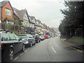
1
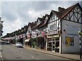
Chalfont St Peter: Market Place
A couple of days after 23 April and a fine array of flags of St George bedeck this mock-Tudor shopping parade with its half-timbered gables dating from 1922. Of course there is always one who bucks the trend!
Image: © Nigel Cox
Taken: 25 Apr 2010
0.01 miles
2
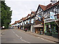
Banners on Market Place for the celebration of St Peter
Cross keys are St Peter's motif. I think this is for June 29th (feast of St Peter and St Paul)
Image: © Bikeboy
Taken: 23 Jun 2012
0.02 miles
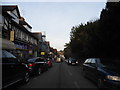
3
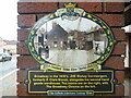
Broadway in the 1930's Plaque
This heritage plaque is fixed on a wall at the east end of the Co-op Shop in Market Place and has an image of Broadway in the 1930's. It also has the following wording:
Broadway in the 1930's. JHE Bishop Ironmongers, formerly P.Clark Stores, alongside his
second hand goods warehouse. Tea rooms are on the right, with The Broadway Cinema on the
left.
Image: © David Hillas
Taken: 26 Aug 2023
0.04 miles
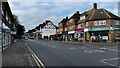
4
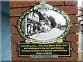
Market Place, formerly Gold Hill Lane Plaque
This heritage plaque is fixed on a wall at the east end of the Co-op Shop in Market Place. It shows an image of Gold Hill Lane c.1900 and the following wording:
Gold Hill Lane c.1900. Now Market Place, then with allotments to the right and Bishop's
Grocers, hardware and second hand furniture shop on the left.
Image: © David Hillas
Taken: 26 Aug 2023
0.04 miles
8
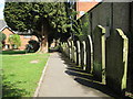
Chalfont St Peter: St Peter's Garden
St Peter's Garden is an old churchyard of Image It is still consecrated ground but, with the permission of the diocese, is now a public open space. The path leads down to Church Lane. I read that there is a list of the burials here on the local parish council website but at the time of submission of this photograph it was not accessible.
Image: © Nigel Cox
Taken: 25 Apr 2010
0.05 miles
9
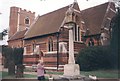
Church at Chalfont St.Peter
In 1708 the medieval church was destroyed by the Tower falling into the nave. A contemporary style church replaced it but was largely altered and extended in the mid 19th century.
Image: © Cered
Taken: 28 Oct 1998
0.06 miles
10
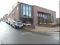
The Hub, Gold Hill Baptist Church, Chalfont St Peter (1)
Situated in Church Lane SL9 9RF, this church opened in September 2021 replacing the one in Gold Hill East, https://www.geograph.org.uk/photo/2065434 refers. It has a large auditorium, a large welcoming foyer, a multi-purpose activity hall, community rooms of various sizes and a terrace looking out to the village at the front.
Image: © David Hillas
Taken: 26 Aug 2023
0.06 miles