
IMAGES TAKEN NEAR TO
Lower Road, GERRARDS CROSS, SL9 9AQ
Introduction
This page details the photographs taken nearby to Lower Road, SL9 9AQ by members of the Geograph project.
The Geograph project started in 2005 with the aim of publishing, organising and preserving representative images for every square kilometre of Great Britain, Ireland and the Isle of Man.

There are currently over 7.5m images from over14,400 individuals and you can help contribute to the project by visiting https://www.geograph.org.uk
Image Map
Images are licensed for reuse under creativecommons.org/licenses/by-sa/2.0
Notes
- Clicking on the map will re-center to the selected point.
- The higher the marker number, the further away the image location is from the centre of the postcode.
Image Listing (80 Images Found)
Images are licensed for reuse under creativecommons.org/licenses/by-sa/2.0
Image
Details
Distance
1

The Grange entrance Plaque at Grange Road
This metal plaque is on an old gate post leading into Grange Road from High Street. It is one of several Celfunde Inheritance Heritage Walk plaques around Chalfont St Peter and has the following wording:
The Grange entrance. The fields beyond are
now the Chalfont Heights estate.
Image: © David Hillas
Taken: 7 Aug 2025
0.02 miles
2
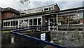
Chalfont St Peter Community Library, High Street
Image: © Bryn Holmes
Taken: 27 Jan 2023
0.09 miles
3

The Old Workhouse Plaque in High Street
This plaque is located on a wall at the east section of High Street opposite a car park. It is one of several heritage plaques around Chalfont St Peter to mark the Diamond Jubilee of Queen Elizabeth's II reign in 2012. It has the following wording:
The old workhouse. Pictured in the 1920's, before
conversion to shops. It was a refuge for the
homeless, but conditions were harsh to deter
scroungers. The gas lamp was moved to the church
porch when the building was demolished.
Image: © David Hillas
Taken: 7 Aug 2025
0.10 miles
4
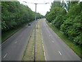
Chalfont St Peter: A413 Amersham Road
This is the view looking from the same Chiltern Hill road bridge as Image but in the opposite direction.
Image: © Nigel Cox
Taken: 24 May 2015
0.10 miles
5

Charabanc Trip Plaque in High Street
This metal plaque is under a brick archway in High Street SL9 9QA. It is one of several plaques on the Celfunde Inheritance Heritage Walk around Chalfont St Peter, and has the following wording:
A party returning from a 'charabanc' coach trip
to the races in 1930. Barrack Yard is to the left,
the Baker's Arms behind.
Image: © David Hillas
Taken: 7 Aug 2025
0.12 miles
6
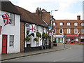
Chalfont St Peter: The White Hart
This pub dates from the 17th century and although it was refaced in the 18th century some of the original structure, such as the brick chimney stack at the far end, still remains. The road is the High Street, once the main A413 road to Amersham, now bypassed by Image The photo was taken a couple of days after St George's Day and the whole town was festooned with flags, albeit some not quite entering into the spirit of things!
Image: © Nigel Cox
Taken: 25 Apr 2010
0.13 miles
7
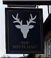
Sign for the White Hart Inn, Chalfont St Peter
Image: © JThomas
Taken: 13 Apr 2019
0.14 miles
8
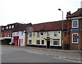
The White Hart Inn, Chalfont St Peter
On High Street.
Image: © JThomas
Taken: 13 Apr 2019
0.14 miles
9
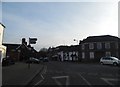
Roundabout on High Street, Chalfont St Peter
Image: © David Howard
Taken: 28 Feb 2013
0.14 miles
10

Fairthorpe Cars Plaque in Market Place
This metal plaque is one of three fixed on a brick post outside Greggs shop in Market Place. It is one of several plaques on the Celfunde Inheritance Heritage Walk around the Chalfont St Peter area and has the following wording:
Fairthorpe Cars. Production was started in 1954 by
Air Vice Marshall Bennett, an RAF pathfinder.
Originally sited where Budgens now stands, it closed
in 1976. Production models included the Atom and
the Electron, as shown here.
Image: © David Hillas
Taken: 7 Aug 2025
0.14 miles