IMAGES TAKEN NEAR TO
Narcot Lane, GERRARDS CROSS, SL9 8TW
Introduction
This page details the photographs taken nearby to Narcot Lane, SL9 8TW by members of the Geograph project.
The Geograph project started in 2005 with the aim of publishing, organising and preserving representative images for every square kilometre of Great Britain, Ireland and the Isle of Man.

There are currently over 7.5m images from over14,400 individuals and you can help contribute to the project by visiting https://www.geograph.org.uk
Image Map
Images are licensed for reuse under creativecommons.org/licenses/by-sa/2.0
Notes
- Clicking on the map will re-center to the selected point.
- The higher the marker number, the further away the image location is from the centre of the postcode.
Image Listing (7 Images Found)
Images are licensed for reuse under creativecommons.org/licenses/by-sa/2.0
Image
Details
Distance
1
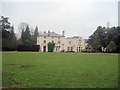
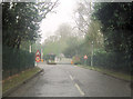
Chalfont Grove
The headquarters of a telecommunications company
Image: © John Firth
Taken: 17 Mar 2012
0.02 miles
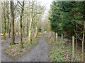
3
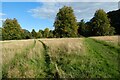
Footpath heading towards Farm Wood
Footpath heading towards Farm Wood by Chalfont Grove
Image: © Shaun Ferguson
Taken: 30 May 2008
0.12 miles
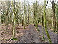
5
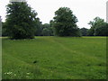
Path, Grove Wood
A public footpath heads this way. There are three parallel paths here, probably the idea is to pick the least muddy one, but there is not much difference.
Image: © Robin Webster
Taken: 27 Mar 2015
0.22 miles
6
Plantation, Grove Wood
A public footpath heads this way. There are three parallel paths here, probably the idea is to pick the least muddy one, but there is not much difference.
Image: © Robin Webster
Taken: 27 Mar 2015
0.23 miles