IMAGES TAKEN NEAR TO
Rickmansworth Lane, GERRARDS CROSS, SL9 0RG
Introduction
This page details the photographs taken nearby to Rickmansworth Lane, SL9 0RG by members of the Geograph project.
The Geograph project started in 2005 with the aim of publishing, organising and preserving representative images for every square kilometre of Great Britain, Ireland and the Isle of Man.

There are currently over 7.5m images from over14,400 individuals and you can help contribute to the project by visiting https://www.geograph.org.uk
Image Map
Images are licensed for reuse under creativecommons.org/licenses/by-sa/2.0
Notes
- Clicking on the map will re-center to the selected point.
- The higher the marker number, the further away the image location is from the centre of the postcode.
Image Listing (20 Images Found)
Images are licensed for reuse under creativecommons.org/licenses/by-sa/2.0
Image
Details
Distance
1
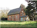
St Paul's Church, Horn Hill
A victorian chapel of ease, within the parish of Chalfont St Peter. More information on page http://www.achurchnearyou.com/venue.php?V=153 on church of England website.
Image: © David Hawgood
Taken: 17 Feb 2006
0.06 miles
2
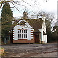
Horn Hill Village Hall and Institute, Chalfont St Peter
Across the road from St Paul's church
Image: © David Hawgood
Taken: 17 Feb 2006
0.06 miles
3
Shire Lane, Horn Hill, Chalfont St Peter, Buckinghamshire
Image: © Christine Matthews
Taken: 14 Aug 2011
0.06 miles
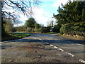
4
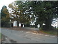
Crossroads on Rickmansworth Road, Horn Hill
Image: © David Howard
Taken: 8 Oct 2015
0.07 miles
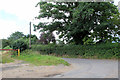
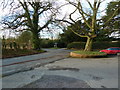
5
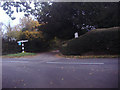
Junction of Rickmansworth Lane and Brawlings Lane
Image: © David Howard
Taken: 2 Nov 2011
0.07 miles
6
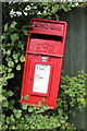
Elizabeth II Postbox, Shire Lane, Horn Hill, Chalfont St Peter, Buckinghamshire
Closer view of the postbox Image] adjacent to the Dumb Bell public house.
Image: © Christine Matthews
Taken: 14 Aug 2011
0.07 miles
7
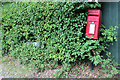
Postbox, Shire Lane, Horn Hill, Chalfont St Peter, Buckinghamshire
The postbox is next door to the Dumb Bell public house.
Image: © Christine Matthews
Taken: 14 Aug 2011
0.07 miles
8
Road junction at Horn Hill Village Hall and Institute
Image: © Alexander P Kapp
Taken: 2 Feb 2013
0.07 miles
9
Road junction at Horn Hill Village Hall and Institute
Image: © Alexander P Kapp
Taken: 2 Feb 2013
0.07 miles
10
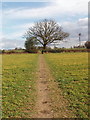
Footpath through crops, Horn Hill
Path from Chalfont Common, view east. The public footpath has been restored to keep it passable through the wheat field.
Image: © David Hawgood
Taken: 17 Feb 2006
0.08 miles