IMAGES TAKEN NEAR TO
Shire Lane, GERRARDS CROSS, SL9 0QX
Introduction
This page details the photographs taken nearby to Shire Lane, SL9 0QX by members of the Geograph project.
The Geograph project started in 2005 with the aim of publishing, organising and preserving representative images for every square kilometre of Great Britain, Ireland and the Isle of Man.

There are currently over 7.5m images from over14,400 individuals and you can help contribute to the project by visiting https://www.geograph.org.uk
Image Map
Images are licensed for reuse under creativecommons.org/licenses/by-sa/2.0
Notes
- Clicking on the map will re-center to the selected point.
- The higher the marker number, the further away the image location is from the centre of the postcode.
Image Listing (20 Images Found)
Images are licensed for reuse under creativecommons.org/licenses/by-sa/2.0
Image
Details
Distance
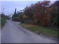
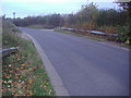
1
Public footpath off Shire Lane, Horn Hill
Image: © David Howard
Taken: 2 Nov 2011
0.03 miles
2
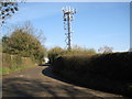
Horn Hill: Telecommunications mast
This one, which is just off Shire Lane, merits its own symbol on the Ordnance Survey 1:50,000 scale map.
Image: © Nigel Cox
Taken: 19 Mar 2011
0.03 miles
3
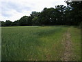
Footpath on edge of field
Footpath on edge of field at Horn Hill
Image: © Shaun Ferguson
Taken: 13 Jun 2008
0.04 miles
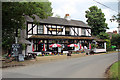
4
The Dumb Bell, Shire Lane, Horn Hill
Image: © Alexander P Kapp
Taken: 2 Feb 2013
0.09 miles
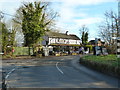
5
The Dumb Bell, Shire Lane, Chalfont St Peter, Buckinghamshire
Situated on Shire Lane near the road junction.
Image: © Christine Matthews
Taken: 14 Aug 2011
0.10 miles
6
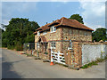
House on Shire Lane
Believed to be new build on the site of an earlier building. It appears to be in the later stages of fitting out here, e.g. no gutter downpipes.
Image: © Robin Webster
Taken: 17 Jul 2013
0.16 miles
8
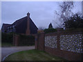
House on Roberts Lane, Chalfont St Peter
Image: © David Howard
Taken: 2 Nov 2011
0.19 miles