IMAGES TAKEN NEAR TO
Shelley Close, MARLOW, SL7 2SE
Introduction
This page details the photographs taken nearby to Shelley Close, SL7 2SE by members of the Geograph project.
The Geograph project started in 2005 with the aim of publishing, organising and preserving representative images for every square kilometre of Great Britain, Ireland and the Isle of Man.

There are currently over 7.5m images from over14,400 individuals and you can help contribute to the project by visiting https://www.geograph.org.uk
Image Map
Images are licensed for reuse under creativecommons.org/licenses/by-sa/2.0
Notes
- Clicking on the map will re-center to the selected point.
- The higher the marker number, the further away the image location is from the centre of the postcode.
Image Listing (13 Images Found)
Images are licensed for reuse under creativecommons.org/licenses/by-sa/2.0
Image
Details
Distance
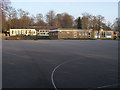
1
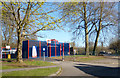
"Airplay" Basketball Court
This is beside Danesfield School.
Image: © Des Blenkinsopp
Taken: 20 Apr 2013
0.04 miles
2
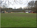
Danesfield School
In the southern corner of Rassler Wood.
Image: © Andrew Smith
Taken: 10 Dec 2006
0.07 miles
3
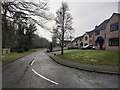
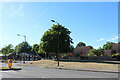
Houses on Thames Reach
Road south of the housing estate near Danesfield School.
Image: © James Emmans
Taken: 25 Feb 2021
0.07 miles
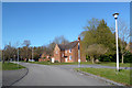
4
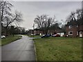
Residential road close to Danesfield School
North close heading south near Rassler Wood.
Image: © James Emmans
Taken: 25 Feb 2021
0.09 miles
5
Danesfield School
Playground of Danesfield School
Image: © Shaun Ferguson
Taken: 29 Dec 2008
0.12 miles
7
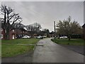
North Close
Housing estate on the Henley Road and south of Hog Wood.
Image: © James Emmans
Taken: 25 Feb 2021
0.13 miles
8
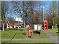
Mail Box, Phone Box and Notice Board
Communications hub at the entrance to Danesfield village.
Image: © Des Blenkinsopp
Taken: 20 Apr 2013
0.14 miles
10
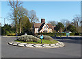
Roundabout & Lodge, Danesfield
One of the entrances, with lodge, to Danesfield House.
Image: © Des Blenkinsopp
Taken: 20 Apr 2013
0.16 miles