IMAGES TAKEN NEAR TO
Henley Road, MARLOW, SL7 2HE
Introduction
This page details the photographs taken nearby to Henley Road, SL7 2HE by members of the Geograph project.
The Geograph project started in 2005 with the aim of publishing, organising and preserving representative images for every square kilometre of Great Britain, Ireland and the Isle of Man.

There are currently over 7.5m images from over14,400 individuals and you can help contribute to the project by visiting https://www.geograph.org.uk
Image Map
Images are licensed for reuse under creativecommons.org/licenses/by-sa/2.0
Notes
- Clicking on the map will re-center to the selected point.
- The higher the marker number, the further away the image location is from the centre of the postcode.
Image Listing (9 Images Found)
Images are licensed for reuse under creativecommons.org/licenses/by-sa/2.0
Image
Details
Distance
1
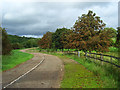
Private road, Medmenham
The private road accessed the former Water Research Centre. Here it is a short distance south of the A4155.
Image: © Andrew Smith
Taken: 6 Sep 2008
0.12 miles
2
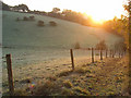
Footpath between Medmenham and Hambleden
Above the A4155 at Westfield where the footpath climbs along the woodland edge between an old chalkpit and pasture in a dry valley.
Image: © Andrew Smith
Taken: 25 Oct 2008
0.13 miles
4
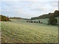
Farmland between Hambleden and Medmenham
Pastures occupy a dry valley stretching north from Westfield.
Image: © Andrew Smith
Taken: 25 Oct 2008
0.18 miles
5
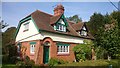
Westfield Cottages
This row of grade II listed estate cottages were built around 1900 and are known for the decorative panels above the front doors depicting scenes of agricultural labour.
http://www.britishlistedbuildings.co.uk/en-47047-11-and-12-westfield-cottages-medmenham-bu#.Vuv6WeaXT8l
Image: © Mark Percy
Taken: 29 Sep 2015
0.19 miles
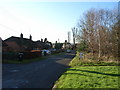
6
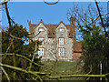
House, Lodge Farm, Medmenham
A grade II*(star) listed building, 17th century.
Image: © Robin Webster
Taken: 2 Feb 2014
0.20 miles
7
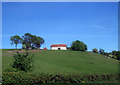
Barn on a Hill
Nothing more to say, really.
Image: © Des Blenkinsopp
Taken: 22 May 2010
0.20 miles
8

Farmland, Medmenham
A permitted footpath follows the edge of this and another arable field to the west of the village.
Image: © Andrew Smith
Taken: 23 Mar 2019
0.21 miles
9
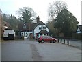
Ye Olde Dog & Badger Public House, Medmenham
Image: © Colin Bates
Taken: 11 Dec 2005
0.22 miles