IMAGES TAKEN NEAR TO
Hockett Lane, MAIDENHEAD, SL6 9UF
Introduction
This page details the photographs taken nearby to Hockett Lane, SL6 9UF by members of the Geograph project.
The Geograph project started in 2005 with the aim of publishing, organising and preserving representative images for every square kilometre of Great Britain, Ireland and the Isle of Man.

There are currently over 7.5m images from over14,400 individuals and you can help contribute to the project by visiting https://www.geograph.org.uk
Image Map
Images are licensed for reuse under creativecommons.org/licenses/by-sa/2.0
Notes
- Clicking on the map will re-center to the selected point.
- The higher the marker number, the further away the image location is from the centre of the postcode.
Image Listing (11 Images Found)
Images are licensed for reuse under creativecommons.org/licenses/by-sa/2.0
Image
Details
Distance
1
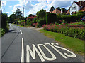
Winter Hill Road, Cookham Dean
Like most of Cookham Dean, a road of spacious detached properties.
Image: © Andrew Smith
Taken: 15 Jun 2008
0.03 miles
4
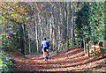
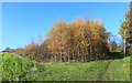
Down into the woods
The start of a steep drop down the scarp towards Bisham.
Image: © Des Blenkinsopp
Taken: 18 Nov 2018
0.18 miles
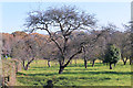
6
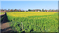
Late Flowering Field
I'm not sure what this is in full bloom in mid November. I'm fairly sure it's not rapeseed. Wrong time of year and the leaves are a different colour.
Image: © Des Blenkinsopp
Taken: 18 Nov 2018
0.22 miles
7
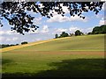
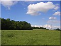
Farmland, Cookham
The valley of Cookhamdean Bottom. The words Bigfrith Common appear on the map but this is privately farmed land. I think the said common is the small area just to the east.
Image: © Andrew Smith
Taken: 15 Jun 2008
0.23 miles
8
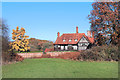
House by the Common
Large house with a view over Cookhamdean Common.
Image: © Des Blenkinsopp
Taken: 18 Nov 2018
0.23 miles
9
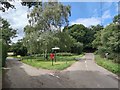
Postbox in Bigfirth
Crossroad west of Cookham Dean.
Image: © James Emmans
Taken: 29 Jul 2020
0.23 miles
10
Farmland, Bisham
The view along the edge of Bisham Woods on emerging from Park Wood. The woodlands are managed by the Woodland Trust and are publicly accessible throughout. The crop is oil-seed rape.
Image: © Andrew Smith
Taken: 15 Jun 2008
0.25 miles