IMAGES TAKEN NEAR TO
Bradcutts Lane, MAIDENHEAD, SL6 9TL
Introduction
This page details the photographs taken nearby to Bradcutts Lane, SL6 9TL by members of the Geograph project.
The Geograph project started in 2005 with the aim of publishing, organising and preserving representative images for every square kilometre of Great Britain, Ireland and the Isle of Man.

There are currently over 7.5m images from over14,400 individuals and you can help contribute to the project by visiting https://www.geograph.org.uk
Image Map
Images are licensed for reuse under creativecommons.org/licenses/by-sa/2.0
Notes
- Clicking on the map will re-center to the selected point.
- The higher the marker number, the further away the image location is from the centre of the postcode.
Image Listing (33 Images Found)
Images are licensed for reuse under creativecommons.org/licenses/by-sa/2.0
Image
Details
Distance
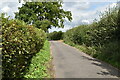
2
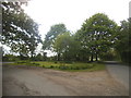
Terrys Lane at the junction of Bradcutts Lane
Image: © David Howard
Taken: 15 May 2016
0.04 miles
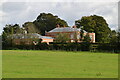
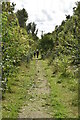
5

Towards Harvest Moon
This seems to be a new house. The grounds were well established yet it seemed to be boarded up. There is a protective fence and hedge all the way round. This section is yew.
Image: © Graham Horn
Taken: 6 Aug 2011
0.08 miles
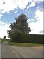
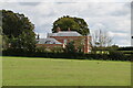
6

Towards Harvest Moon
This is a large house but also a relatively modern one called Harvest Moon. Looking across the fields from the Winter Hill to Hillgrove Farm footpath.
Image: © Graham Horn
Taken: 6 Aug 2011
0.09 miles