IMAGES TAKEN NEAR TO
Berries Road, MAIDENHEAD, SL6 9SD
Introduction
This page details the photographs taken nearby to Berries Road, SL6 9SD by members of the Geograph project.
The Geograph project started in 2005 with the aim of publishing, organising and preserving representative images for every square kilometre of Great Britain, Ireland and the Isle of Man.

There are currently over 7.5m images from over14,400 individuals and you can help contribute to the project by visiting https://www.geograph.org.uk
Image Map
Images are licensed for reuse under creativecommons.org/licenses/by-sa/2.0
Notes
- Clicking on the map will re-center to the selected point.
- The higher the marker number, the further away the image location is from the centre of the postcode.
Image Listing (209 Images Found)
Images are licensed for reuse under creativecommons.org/licenses/by-sa/2.0
Image
Details
Distance
2

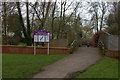
Holy Trinity Church, Cookham
Cookham was the home of Sir Stanley Spencer and has a gallery of his works.
Image: © Andrew Smith
Taken: 20 Nov 2005
0.08 miles
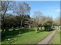
3
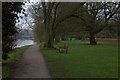
Bell Rope Meadow
Cookham Bridge in the background
Image: © Robert Eva
Taken: 11 Mar 2017
0.09 miles

5
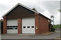
Cookham Fire Station
Cookham Fire Station, Berries Road, Cookham, Berkshire
Image: © Kevin Hale
Taken: 8 May 2007
0.10 miles
7
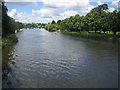
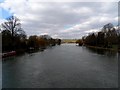
River Thames at Cookham
Viewed looking upstream from Cookham Bridge, the centre of the river is also the boundary between Berkshire to the left and Buckinghamshire to the right.
Image: © Nigel Cox
Taken: 8 Jul 2007
0.11 miles
9
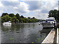
The River Thames, Cookham
Looking towards Cookham Bridge which is just about visible behind the moored boat.
Image: © Andrew Smith
Taken: 8 Aug 2009
0.11 miles
10
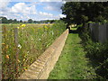
Cookham: Flood defence wall
Cookham has always been prone to flooding from the River Thames, and the flood events of November 1894 and March 1947 caused severe inundation and damage. This is the flood defence wall along the western side of Cookham, constructed by the Environment Agency in 2002/3. Beyond the wall to the left is Cookham Moor leading down to the Thames in the distance, marked by the sails on dinghies. On this side to the right is the protected area of the town.
Image: © Nigel Cox
Taken: 8 Jul 2007
0.12 miles