IMAGES TAKEN NEAR TO
Sutton Road, MAIDENHEAD, SL6 9RB
Introduction
This page details the photographs taken nearby to Sutton Road, SL6 9RB by members of the Geograph project.
The Geograph project started in 2005 with the aim of publishing, organising and preserving representative images for every square kilometre of Great Britain, Ireland and the Isle of Man.

There are currently over 7.5m images from over14,400 individuals and you can help contribute to the project by visiting https://www.geograph.org.uk
Image Map
Images are licensed for reuse under creativecommons.org/licenses/by-sa/2.0
Notes
- Clicking on the map will re-center to the selected point.
- The higher the marker number, the further away the image location is from the centre of the postcode.
Image Listing (10 Images Found)
Images are licensed for reuse under creativecommons.org/licenses/by-sa/2.0
Image
Details
Distance

5
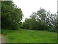
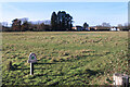
Widbrook Common
An area of marshy grassland owned by the National Trust. The water is part of the White Brook which flows through the common.
Two versions of the same name. White or wide? In fact neither. The National trust page https://www.nationaltrust.org.uk/maidenhead-and-cookham-commons/features/widbrook-common-at-cookham-commons says "The name Widbrook is derived from the stream that flows through it linking the River Thames and the Strand Water which continues north to Cookham Moor. The stream is now known as the White Brook, which was itself derived from the traditional name for the stream, Withe-brook.
A withe, pronounced withy, is a strong flexible willow stem used in thatching and horticulture. It is the willow trees that are still found along the banks of the stream today that gave the common its name."
The link also has information about the ancient grazing regime which still goes on here and which has preserved the biodiversity of the site.
Image: © Des Blenkinsopp
Taken: 1 Dec 2020
0.11 miles
7

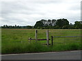
Widbrook Common
This is a field but for public use
Image: © David Howard
Taken: 12 Jul 2015
0.12 miles
8
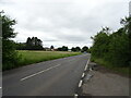
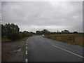
A4094 Lower Cookham Road
Towards Cookham and Bourne End.
Image: © Robin Webster
Taken: 9 Jun 2019
0.15 miles
9
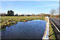
National Trust, Widbrook Common
An expanse of marshy grassland owned by the National Trust, where ancient grazing rights have protected the site's biodiversity.
https://www.nationaltrust.org.uk/maidenhead-and-cookham-commons/features/widbrook-common-at-cookham-commons
Image: © Des Blenkinsopp
Taken: 1 Dec 2020
0.17 miles
10

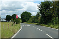
A4094 Lower Cookham Road
Towards Cookham and Bourne End.
Image: © Robin Webster
Taken: 9 Jun 2019
0.25 miles