IMAGES TAKEN NEAR TO
Whyteladyes Lane, MAIDENHEAD, SL6 9LP
Introduction
This page details the photographs taken nearby to Whyteladyes Lane, SL6 9LP by members of the Geograph project.
The Geograph project started in 2005 with the aim of publishing, organising and preserving representative images for every square kilometre of Great Britain, Ireland and the Isle of Man.

There are currently over 7.5m images from over14,400 individuals and you can help contribute to the project by visiting https://www.geograph.org.uk
Image Map
Images are licensed for reuse under creativecommons.org/licenses/by-sa/2.0
Notes
- Clicking on the map will re-center to the selected point.
- The higher the marker number, the further away the image location is from the centre of the postcode.
Image Listing (11 Images Found)
Images are licensed for reuse under creativecommons.org/licenses/by-sa/2.0
Image
Details
Distance
1
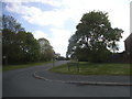
Whiteladyes Lane at the junction of Maidenhead Road
Image: © David Howard
Taken: 15 May 2016
0.12 miles
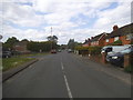
3
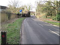
Railway bridge over Maidenhead Road, Cookham Dean
Image: © Nigel Thompson
Taken: 7 Feb 2013
0.16 miles
4
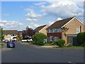
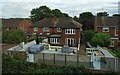
Broom Hill, Cookham Rise
The entrance to the estate off Whyteladyes Lane.
Image: © Andrew Smith
Taken: 15 Jun 2008
0.17 miles
7
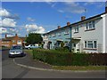
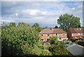
Lester Road, Cookham Rise
Houses on the western extremity of Cookham Rise.
Image: © Andrew Smith
Taken: 15 Jun 2008
0.22 miles
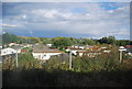
9
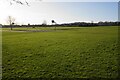
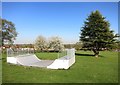
The Alfred Major Recreation Ground
A very large area of open green space surrounded by housing.
Image: © Bill Boaden
Taken: 26 Jan 2024
0.23 miles