IMAGES TAKEN NEAR TO
High Road, MAIDENHEAD, SL6 9HZ
Introduction
This page details the photographs taken nearby to High Road, SL6 9HZ by members of the Geograph project.
The Geograph project started in 2005 with the aim of publishing, organising and preserving representative images for every square kilometre of Great Britain, Ireland and the Isle of Man.

There are currently over 7.5m images from over14,400 individuals and you can help contribute to the project by visiting https://www.geograph.org.uk
Image Map
Images are licensed for reuse under creativecommons.org/licenses/by-sa/2.0
Notes
- Clicking on the map will re-center to the selected point.
- The higher the marker number, the further away the image location is from the centre of the postcode.
Image Listing (54 Images Found)
Images are licensed for reuse under creativecommons.org/licenses/by-sa/2.0
Image
Details
Distance
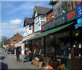
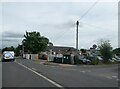
1
Lower Road, Cookham Rise
Showing the post-office at the junction with Grange Road.
Image: © Andrew Smith
Taken: 15 Jun 2008
0.03 miles
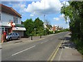
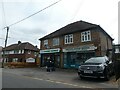
2

Lower Road, Cookham Rise
A small row of shops across the road from the junction with Coxborrow Close.
Image: © Andrew Smith
Taken: 15 Jun 2008
0.03 miles
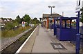
4
Cookham Station and level crossing
Looking northwards up the Maidenhead to Marlow branch line
Image: © Andrew Smith
Taken: 20 Nov 2005
0.07 miles
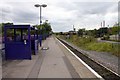
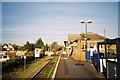
8
Cookham Railway Station: early July 2024
Image: © Basher Eyre
Taken: 3 Jul 2024
0.10 miles
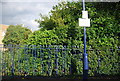
9

Stop board and level crossing at Cookham Station
Image: © Steve Daniels
Taken: 20 Sep 2009
0.10 miles