IMAGES TAKEN NEAR TO
Dean Lane, MAIDENHEAD, SL6 9BB
Introduction
This page details the photographs taken nearby to Dean Lane, SL6 9BB by members of the Geograph project.
The Geograph project started in 2005 with the aim of publishing, organising and preserving representative images for every square kilometre of Great Britain, Ireland and the Isle of Man.

There are currently over 7.5m images from over14,400 individuals and you can help contribute to the project by visiting https://www.geograph.org.uk
Image Map
Images are licensed for reuse under creativecommons.org/licenses/by-sa/2.0
Notes
- Clicking on the map will re-center to the selected point.
- The higher the marker number, the further away the image location is from the centre of the postcode.
Image Listing (18 Images Found)
Images are licensed for reuse under creativecommons.org/licenses/by-sa/2.0
Image
Details
Distance
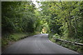
1
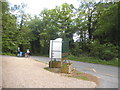
The entrance to Herries School on Dean Lane
Image: © David Howard
Taken: 15 May 2016
0.03 miles
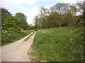
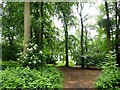
2
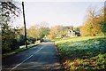
Cookham Dean
This patch of common, like much in the area, is National Trust property.
Image: © Andrew Smith
Taken: 20 Nov 2005
0.07 miles
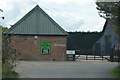
7
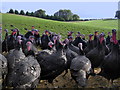
Kings Coppice Farm
Kings Coppice Farm is the home of Copas Turkeys.
Image: © Mark Percy
Taken: 16 Oct 2010
0.15 miles
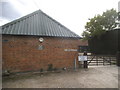
8
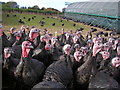
Kings Coppice Farm
Kings Coppice Farm is the home of Copas Turkeys.
Image: © Mark Percy
Taken: 16 Oct 2010
0.15 miles
10
Quarry Wood, near the main entrance point
Image: © David Gearing
Taken: 8 Jun 2016
0.18 miles