IMAGES TAKEN NEAR TO
Alleyns Lane, MAIDENHEAD, SL6 9AE
Introduction
This page details the photographs taken nearby to Alleyns Lane, SL6 9AE by members of the Geograph project.
The Geograph project started in 2005 with the aim of publishing, organising and preserving representative images for every square kilometre of Great Britain, Ireland and the Isle of Man.

There are currently over 7.5m images from over14,400 individuals and you can help contribute to the project by visiting https://www.geograph.org.uk
Image Map
Images are licensed for reuse under creativecommons.org/licenses/by-sa/2.0
Notes
- Clicking on the map will re-center to the selected point.
- The higher the marker number, the further away the image location is from the centre of the postcode.
Image Listing (25 Images Found)
Images are licensed for reuse under creativecommons.org/licenses/by-sa/2.0
Image
Details
Distance
1

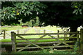
Horse chestnut and chestnut horse
The horse chestnut tree hangs above us. In the field a chestnut horse grazes. Don't confuse the two.
Image: © Graham Horn
Taken: 6 Aug 2011
0.08 miles

6
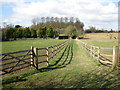
Footpath at Hillgrove Farm
This footpath heads north-west towards Winter Hill. Here it starts by crossing a paddock underneath a fine horse chestnut tree.
Image: © Graham Horn
Taken: 6 Aug 2011
0.14 miles