IMAGES TAKEN NEAR TO
Bridle Road, MAIDENHEAD, SL6 7RT
Introduction
This page details the photographs taken nearby to Bridle Road, SL6 7RT by members of the Geograph project.
The Geograph project started in 2005 with the aim of publishing, organising and preserving representative images for every square kilometre of Great Britain, Ireland and the Isle of Man.

There are currently over 7.5m images from over14,400 individuals and you can help contribute to the project by visiting https://www.geograph.org.uk
Image Map
Images are licensed for reuse under creativecommons.org/licenses/by-sa/2.0
Notes
- Clicking on the map will re-center to the selected point.
- The higher the marker number, the further away the image location is from the centre of the postcode.
Image Listing (44 Images Found)
Images are licensed for reuse under creativecommons.org/licenses/by-sa/2.0
Image
Details
Distance
6
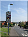
Level Crossing warning signs, Harrow Lane, Furze Platt
Image: © SK53
Taken: 16 Apr 2014
0.07 miles
10
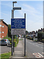
Level Crossing signage, Harrow Lane Furze Platt
The Marlow-Maidenhead branch line (the 'Marlow Donkey') usually has only 1 train an hour in each direction, and therefore the existing level crossings ought to be relatively untroubled. However this one at Furze Platt seems to have many problem incidents recently. An industrial estate (Cordwallis Estate) lies just to the South and modern satnavs may be routing large vehicles along Harrow Lane as a short-cut.
Image: © SK53
Taken: 16 Apr 2014
0.10 miles