IMAGES TAKEN NEAR TO
Nightingale Lane, MAIDENHEAD, SL6 7QL
Introduction
This page details the photographs taken nearby to Nightingale Lane, SL6 7QL by members of the Geograph project.
The Geograph project started in 2005 with the aim of publishing, organising and preserving representative images for every square kilometre of Great Britain, Ireland and the Isle of Man.

There are currently over 7.5m images from over14,400 individuals and you can help contribute to the project by visiting https://www.geograph.org.uk
Image Map
Images are licensed for reuse under creativecommons.org/licenses/by-sa/2.0
Notes
- Clicking on the map will re-center to the selected point.
- The higher the marker number, the further away the image location is from the centre of the postcode.
Image Listing (5 Images Found)
Images are licensed for reuse under creativecommons.org/licenses/by-sa/2.0
Image
Details
Distance
1
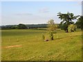
Fields, Cookham
To the north of Nightingale Lane, a restricted byway marking the northern edge of the Furze Platt area of Maidenhead.
Image: © Andrew Smith
Taken: 15 Jun 2008
0.07 miles

3
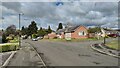
Hungerford Drive
Bungalows on the northern edge of Maidenhead.
Image: © James Emmans
Taken: 4 May 2021
0.22 miles
4
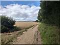
Hindhay Lane
Farm track used as part of the Cookham Bridleway Circuit trail.
Image: © James Emmans
Taken: 29 Jul 2020
0.23 miles
5
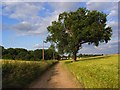
Hindhay Lane, Maidenhead
An oak tree beside a restricted byway just outside of Maidenhead's built-up area.
Image: © Andrew Smith
Taken: 15 Jun 2008
0.25 miles