IMAGES TAKEN NEAR TO
Kinghorn Lane, MAIDENHEAD, SL6 7QG
Introduction
This page details the photographs taken nearby to Kinghorn Lane, SL6 7QG by members of the Geograph project.
The Geograph project started in 2005 with the aim of publishing, organising and preserving representative images for every square kilometre of Great Britain, Ireland and the Isle of Man.

There are currently over 7.5m images from over14,400 individuals and you can help contribute to the project by visiting https://www.geograph.org.uk
Image Map
Images are licensed for reuse under creativecommons.org/licenses/by-sa/2.0
Notes
- Clicking on the map will re-center to the selected point.
- The higher the marker number, the further away the image location is from the centre of the postcode.
Image Listing (7 Images Found)
Images are licensed for reuse under creativecommons.org/licenses/by-sa/2.0
Image
Details
Distance
1

Cliveden View Shopping Centre
A co-op, a post office and two or three other shops. It probably is possible to see Cliveden from here, although I didn't actually look.
Image: © Des Blenkinsopp
Taken: 18 Nov 2018
0.13 miles
2
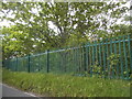
Woods by Maidenhead Road, Furze Platt
It's alongside the railway line
Image: © David Howard
Taken: 15 May 2016
0.14 miles
3
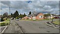
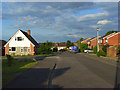
Hungerford Drive
Bungalows on the northern edge of Maidenhead.
Image: © James Emmans
Taken: 4 May 2021
0.17 miles
4
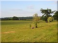
Fields, Cookham
To the north of Nightingale Lane, a restricted byway marking the northern edge of the Furze Platt area of Maidenhead.
Image: © Andrew Smith
Taken: 15 Jun 2008
0.18 miles
5
Gardner Road, Maidenhead
The B4447 heading west from the railway. The B4447 is the road to Cookham though here it takes an indirect course and Cookham Road goes north.
Image: © Andrew Smith
Taken: 15 Jun 2008
0.19 miles
6
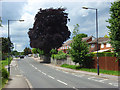
Hungerford Drive, Maidenhead
Suburbia at the northern extremity of the town. Arable field are immediately to the north.
Image: © Andrew Smith
Taken: 15 Jun 2008
0.22 miles
7
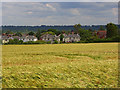
Barley and houses, Maidenhead
Looking down to houses on Cannon Court Road. In the background is the wooded hillside above the Thames at Taplow.
Image: © Andrew Smith
Taken: 15 Jun 2008
0.23 miles