IMAGES TAKEN NEAR TO
Avondale, MAIDENHEAD, SL6 6SE
Introduction
This page details the photographs taken nearby to Avondale, SL6 6SE by members of the Geograph project.
The Geograph project started in 2005 with the aim of publishing, organising and preserving representative images for every square kilometre of Great Britain, Ireland and the Isle of Man.

There are currently over 7.5m images from over14,400 individuals and you can help contribute to the project by visiting https://www.geograph.org.uk
Image Map
Images are licensed for reuse under creativecommons.org/licenses/by-sa/2.0
Notes
- Clicking on the map will re-center to the selected point.
- The higher the marker number, the further away the image location is from the centre of the postcode.
Image Listing (7 Images Found)
Images are licensed for reuse under creativecommons.org/licenses/by-sa/2.0
Image
Details
Distance
1
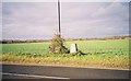
Farmland and trig point, northern edge of Maidenhead
Image: © Andrew Smith
Taken: 4 Dec 2005
0.16 miles
2
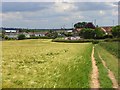
Urban fringe, Maidenhead
Arable fields abut the Furze Platt district of the town. The curving course of the A308, Furze Platt Road, can be seen as it approaches Switchback Road.
Image: © Andrew Smith
Taken: 15 Jun 2008
0.18 miles
3
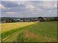
Wheat and barley, Maidenhead
With the footpath climbing northwest from Furze Platt Road.
Image: © Andrew Smith
Taken: 15 Jun 2008
0.18 miles
5
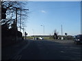
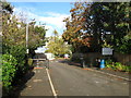
Furze Platt Road at the junction of Gardner Road
Image: © David Howard
Taken: 13 Mar 2016
0.22 miles
6
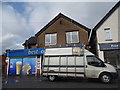
Best-one grocers on Gringer Hill, Furze Platt
Image: © David Howard
Taken: 12 Jul 2015
0.22 miles
7
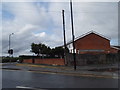
Gringer Hill at the junction of Switchback Road South
Image: © David Howard
Taken: 12 Jul 2015
0.23 miles