IMAGES TAKEN NEAR TO
Honey Lane, MAIDENHEAD, SL6 6RH
Introduction
This page details the photographs taken nearby to Honey Lane, SL6 6RH by members of the Geograph project.
The Geograph project started in 2005 with the aim of publishing, organising and preserving representative images for every square kilometre of Great Britain, Ireland and the Isle of Man.

There are currently over 7.5m images from over14,400 individuals and you can help contribute to the project by visiting https://www.geograph.org.uk
Image Map
Images are licensed for reuse under creativecommons.org/licenses/by-sa/2.0
Notes
- Clicking on the map will re-center to the selected point.
- The higher the marker number, the further away the image location is from the centre of the postcode.
Image Listing (10 Images Found)
Images are licensed for reuse under creativecommons.org/licenses/by-sa/2.0
Image
Details
Distance
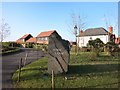
2
No Entrance to the Show
To be fair, it doesn't much look like it might be, but there's always some people who'll try their luck.
This track is a very back way into the Berkshire College of Agriculture site.
Image: © Des Blenkinsopp
Taken: 16 Jan 2015
0.10 miles
3
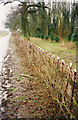
Hedge Laying 1995
This thin, weak hedge has been laid to strengthen and thicken it up. The whitish face of the angled uprights is sometimes referred to as the 'shining'.
Image: © john shortland
Taken: Unknown
0.18 miles
4
New houses on the site of Hallplace Farm
Looking east from the bridle path. The housing development has taken the name Home Farm rather than the name of the farm it replaced.
Image: © Simon Mortimer
Taken: 12 Jan 2020
0.21 miles
5
Seems to be Home Farm now
The map still calls this Top Farm but Home Farm seems more appropriate seeing as it's all houses now.
This picture from 2006 shows what was here before. Image
Image: © Des Blenkinsopp
Taken: 16 Jan 2015
0.23 miles
6
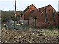
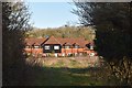
Farm buildings, Top Farm
Part of Berkshire College of Agriculture.
Image: © Andrew Smith
Taken: 2 Dec 2006
0.24 miles
7
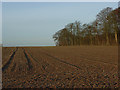
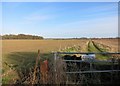
Farmland above Hurley
Beside High Wood.
Image: © Andrew Smith
Taken: 10 Dec 2006
0.24 miles
8
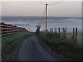
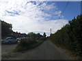
Honey Lane
Just before the steep drop to Hurley.
Image: © Andrew Smith
Taken: 10 Dec 2006
0.25 miles
9
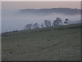
Prospect Hill
Looking across to the wooded scarp between Bisham and Cookham.
Image: © Andrew Smith
Taken: 10 Dec 2006
0.25 miles
10
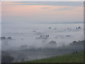
View from Prospect Hill, Hurley
Looking towards Bisham and Marlow in a misty Thames valley.
Image: © Andrew Smith
Taken: 19 Oct 2008
0.25 miles