IMAGES TAKEN NEAR TO
Honey Lane, MAIDENHEAD, SL6 6RE
Introduction
This page details the photographs taken nearby to Honey Lane, SL6 6RE by members of the Geograph project.
The Geograph project started in 2005 with the aim of publishing, organising and preserving representative images for every square kilometre of Great Britain, Ireland and the Isle of Man.

There are currently over 7.5m images from over14,400 individuals and you can help contribute to the project by visiting https://www.geograph.org.uk
Image Map
Images are licensed for reuse under creativecommons.org/licenses/by-sa/2.0
Notes
- Clicking on the map will re-center to the selected point.
- The higher the marker number, the further away the image location is from the centre of the postcode.
Image Listing (6 Images Found)
Images are licensed for reuse under creativecommons.org/licenses/by-sa/2.0
Image
Details
Distance
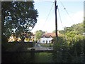
3
Parkland, Hall Place
Part of the Berkshire College of Agriculture's grounds.
Image: © Andrew Smith
Taken: 2 Dec 2006
0.14 miles
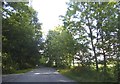
4
Farmland towards Burchett's Green
The view opens up from the edge of the forest at Ashley Hill.
Image: © don cload
Taken: 11 Apr 2009
0.22 miles
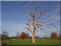
5
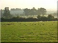
Farmland, Burchetts Green
The pastures of Berkshire College of Agriculture with slight morning mist.
Image: © Andrew Smith
Taken: 13 Sep 2007
0.22 miles
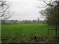
6
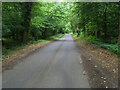
Honey Lane
Honey Lane passing through the Ridings part of Ashley Hill Forest.
Image: © Shaun Ferguson
Taken: 12 Jun 2009
0.24 miles