IMAGES TAKEN NEAR TO
Camley Park Drive, MAIDENHEAD, SL6 6QF
Introduction
This page details the photographs taken nearby to Camley Park Drive, SL6 6QF by members of the Geograph project.
The Geograph project started in 2005 with the aim of publishing, organising and preserving representative images for every square kilometre of Great Britain, Ireland and the Isle of Man.

There are currently over 7.5m images from over14,400 individuals and you can help contribute to the project by visiting https://www.geograph.org.uk
Image Map
Images are licensed for reuse under creativecommons.org/licenses/by-sa/2.0
Notes
- Clicking on the map will re-center to the selected point.
- The higher the marker number, the further away the image location is from the centre of the postcode.
Image Listing (3 Images Found)
Images are licensed for reuse under creativecommons.org/licenses/by-sa/2.0
Image
Details
Distance
2

Misty dawn, Maidenhead Thicket
The National Trust owns 843 acres of commonland and greens to the west and north of Maidenhead.
Image: © Andrew Smith
Taken: 14 Nov 2005
0.23 miles
3
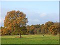
Pinkneys Green
The entirety of this picture (other than the dog-walker), like 843 acres hereabouts, is National Trust property. The woodland is on the northern side of Pinkneys Drive. Come here early in the day without a dog and you'll feel out-of-place.
Image: © Andrew Smith
Taken: 9 Nov 2007
0.23 miles