IMAGES TAKEN NEAR TO
Furze Platt Road, MAIDENHEAD, SL6 6PZ
Introduction
This page details the photographs taken nearby to Furze Platt Road, SL6 6PZ by members of the Geograph project.
The Geograph project started in 2005 with the aim of publishing, organising and preserving representative images for every square kilometre of Great Britain, Ireland and the Isle of Man.

There are currently over 7.5m images from over14,400 individuals and you can help contribute to the project by visiting https://www.geograph.org.uk
Image Map
Images are licensed for reuse under creativecommons.org/licenses/by-sa/2.0
Notes
- Clicking on the map will re-center to the selected point.
- The higher the marker number, the further away the image location is from the centre of the postcode.
Image Listing (9 Images Found)
Images are licensed for reuse under creativecommons.org/licenses/by-sa/2.0
Image
Details
Distance
2
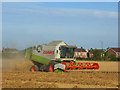
Harvest, Pinkneys Green
A field of wheat to the north of the A308 and suburban Maidenhead.
Image: © Andrew Smith
Taken: 30 Jul 2008
0.06 miles
3
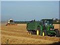
Harvest, Pinkneys Green
A tractor awaits the next load of grain in a field east of Pinkneys Farm. Maidenhead's suburbia starts beyond this field.
Image: © Andrew Smith
Taken: 30 Jul 2008
0.07 miles
4
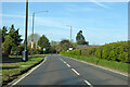
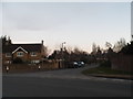
A308 Furze Platt Road
Towards Marlow.
Image: © Robin Webster
Taken: 18 Apr 2021
0.09 miles
5
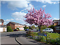
Knowsley Close at the junction of Furze Platt Road
Image: © David Howard
Taken: 20 Mar 2016
0.09 miles
6
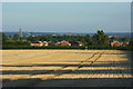
Harvested farmland, Pinkney's Green
A field between Hindhay Farm and Pinkneys Farm with a view of Maidenhead including All Saints' church's scaffolded spire.
Image: © Andrew Smith
Taken: 30 Jul 2008
0.12 miles

9
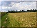
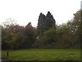
Barley and footpath near Pinkneys Green
The footpath approaching Pinkneys Green from the ENE. The trees are at the point where the farm is reached. Intervening fields of wheat and horses are hidden from view.
Image: © Andrew Smith
Taken: 15 Jun 2008
0.21 miles