IMAGES TAKEN NEAR TO
Choke Lane, MAIDENHEAD, SL6 6PN
Introduction
This page details the photographs taken nearby to Choke Lane, SL6 6PN by members of the Geograph project.
The Geograph project started in 2005 with the aim of publishing, organising and preserving representative images for every square kilometre of Great Britain, Ireland and the Isle of Man.

There are currently over 7.5m images from over14,400 individuals and you can help contribute to the project by visiting https://www.geograph.org.uk
Image Map
Images are licensed for reuse under creativecommons.org/licenses/by-sa/2.0
Notes
- Clicking on the map will re-center to the selected point.
- The higher the marker number, the further away the image location is from the centre of the postcode.
Image Listing (14 Images Found)
Images are licensed for reuse under creativecommons.org/licenses/by-sa/2.0
Image
Details
Distance
5
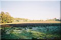
Butler's Gate
Looking across a meadow to houses in Choke Lane.
Image: © Andrew Smith
Taken: 20 Nov 2005
0.13 miles
6
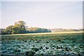
Cookham Dean Common
Frost persisting all day in the shade.
Image: © Andrew Smith
Taken: 20 Nov 2005
0.14 miles
7
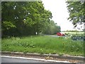
Winter Hill Road looking towards Choke Lane
Image: © David Howard
Taken: 15 May 2016
0.14 miles
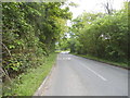
9
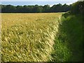
Barley, Cookham
Beside the footpath south of Mount Farm.
Image: © Andrew Smith
Taken: 15 Jun 2008
0.17 miles
10
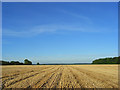
Stubble, Cookham
Harvested barley south of Mount Farm with Beeching-grove Wood to the right.
Image: © Andrew Smith
Taken: 30 Jul 2008
0.21 miles