IMAGES TAKEN NEAR TO
Marlow Road, MAIDENHEAD, SL6 6PH
Introduction
This page details the photographs taken nearby to Marlow Road, SL6 6PH by members of the Geograph project.
The Geograph project started in 2005 with the aim of publishing, organising and preserving representative images for every square kilometre of Great Britain, Ireland and the Isle of Man.

There are currently over 7.5m images from over14,400 individuals and you can help contribute to the project by visiting https://www.geograph.org.uk
Image Map
Images are licensed for reuse under creativecommons.org/licenses/by-sa/2.0
Notes
- Clicking on the map will re-center to the selected point.
- The higher the marker number, the further away the image location is from the centre of the postcode.
Image Listing (6 Images Found)
Images are licensed for reuse under creativecommons.org/licenses/by-sa/2.0
Image
Details
Distance
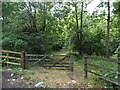
1
Track towards Park Farm
Dirt access road through woodland.
Image: © James Emmans
Taken: 24 Jun 2020
0.14 miles
2
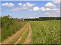
Farmland and footpath, Bisham
Passing through a field of oil-seed rape to the east of Park Farm. The track is also a permissive bridleway.
Image: © Andrew Smith
Taken: 15 Jun 2008
0.17 miles
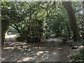
3
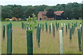
Towards Park Farm
From a footpath to Park Wood. There is the start of a new plantation here, with many young trees wrapped in their protective plastic sheaths.
Image: © Graham Horn
Taken: 6 Aug 2011
0.22 miles