IMAGES TAKEN NEAR TO
Lee Lane, MAIDENHEAD, SL6 6PE
Introduction
This page details the photographs taken nearby to Lee Lane, SL6 6PE by members of the Geograph project.
The Geograph project started in 2005 with the aim of publishing, organising and preserving representative images for every square kilometre of Great Britain, Ireland and the Isle of Man.

There are currently over 7.5m images from over14,400 individuals and you can help contribute to the project by visiting https://www.geograph.org.uk
Image Map
Images are licensed for reuse under creativecommons.org/licenses/by-sa/2.0
Notes
- Clicking on the map will re-center to the selected point.
- The higher the marker number, the further away the image location is from the centre of the postcode.
Image Listing (6 Images Found)
Images are licensed for reuse under creativecommons.org/licenses/by-sa/2.0
Image
Details
Distance
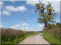
1

Lee Lane passes Lee Farm
Farm north west of the Maidenhead suburbs.
Image: © James Emmans
Taken: 25 Feb 2021
0.04 miles
3
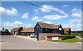
Hall Place Veterinary Centre
Part of the cluster of buildings at Lee Farm.
Image: © Des Blenkinsopp
Taken: 14 Apr 2014
0.10 miles
4
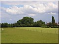
Fields, Bisham
To the south of Lee Farm where horses graze and hay has been mown.
Image: © Andrew Smith
Taken: 15 Jun 2008
0.18 miles
5
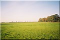
Farmland north of Maidenhead
Looking across fields towards Hyde Farm.
Image: © Andrew Smith
Taken: 20 Nov 2005
0.20 miles
6
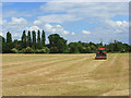
Farmland, Bisham
A mown hay field at Pinkneys Court now being rolled.
Image: © Andrew Smith
Taken: 15 Jun 2008
0.20 miles