IMAGES TAKEN NEAR TO
Malders Lane, MAIDENHEAD, SL6 6NQ
Introduction
This page details the photographs taken nearby to Malders Lane, SL6 6NQ by members of the Geograph project.
The Geograph project started in 2005 with the aim of publishing, organising and preserving representative images for every square kilometre of Great Britain, Ireland and the Isle of Man.

There are currently over 7.5m images from over14,400 individuals and you can help contribute to the project by visiting https://www.geograph.org.uk
Image Map
Images are licensed for reuse under creativecommons.org/licenses/by-sa/2.0
Notes
- Clicking on the map will re-center to the selected point.
- The higher the marker number, the further away the image location is from the centre of the postcode.
Image Listing (9 Images Found)
Images are licensed for reuse under creativecommons.org/licenses/by-sa/2.0
Image
Details
Distance
1
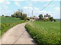
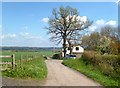
House by Malders Lane
Malders Lane is an unsurfaced but quite good track serving a couple of houses and farms.
Image: © Des Blenkinsopp
Taken: 14 Apr 2014
0.09 miles
2
Footpath passing Hindley Quarry
Hindley Quarry is Berkshire's only chalk quarry that is used for agricultural lime.
Image: © James Emmans
Taken: 29 Jul 2020
0.13 miles
3
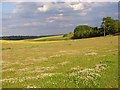
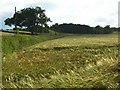
Farmland, Maidenhead
Pasture between Hindhay Lane and Malders Lane. Beyond are fields of barley either side of Hindhay Lane.
Image: © Andrew Smith
Taken: 15 Jun 2008
0.16 miles
4
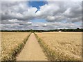
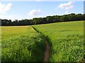
Bridleway Crosses the Wheat Fields
The bridleway is called Hindhay Lane .
Image: © James Emmans
Taken: 29 Jul 2020
0.16 miles
5
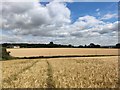
Farmland, Maidenhead
Barley on the northern side of Hindhay Lane.
Image: © Andrew Smith
Taken: 15 Jun 2008
0.19 miles
6
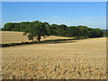
Farmland and copse, Maidenhead
Harvested barley fields viewed from just above Hindhay Lane.
Image: © Andrew Smith
Taken: 30 Jul 2008
0.20 miles
7
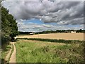
Footpath, Cookham
Crossing a field of barley to the south of Beeching-grove Wood.
Image: © Andrew Smith
Taken: 15 Jun 2008
0.22 miles
8
House on Malders Lane
Malders Lane is an unsurfaced but quite good track serving a couple of houses and farms.
Image: © Des Blenkinsopp
Taken: 14 Apr 2014
0.22 miles