IMAGES TAKEN NEAR TO
Malders Lane, MAIDENHEAD, SL6 6NJ

Introduction

This page details the photographs taken nearby to Malders Lane, SL6 6NJ by members of the Geograph project.

The Geograph project started in 2005 with the aim of publishing, organising and preserving representative images for every square kilometre of Great Britain, Ireland and the Isle of Man.

There are currently over 7.5m images from over14,400 individuals and you can help contribute to the project by visiting https://www.geograph.org.uk

Image Map


Images are licensed for reuse under creativecommons.org/licenses/by-sa/2.0
Notes
  • Clicking on the map will re-center to the selected point.
  • The higher the marker number, the further away the image location is from the centre of the postcode.

Image Listing (9 Images Found)

Images are licensed for reuse under creativecommons.org/licenses/by-sa/2.0
Image
Details
Distance
1
Kiln Place, Pinkneys Green
New housing over the road from the site of the old Maidenhead Brick and Tile Company's works, hence the name.
Image: © Des Blenkinsopp Taken: 14 Apr 2014
0.01 miles
2
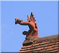
Dragon on the Roof
This is on a house next to the site of the former Maidenhead Brick and Tile Works. They produced not just bricks and tiles, but all sorts of decorative adornments such as this, for the roofline with everything.
Image: © Des Blenkinsopp Taken: 13 Apr 2014
0.11 miles
3
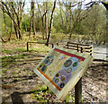
Nature Reserve Notice
The site of the former Maidenhead Brick and Tile Company's brickworks has been allowed to go back to nature. Several ponds are on the reserve in the old clay pits.
Image: © Des Blenkinsopp Taken: 14 Apr 2014
0.14 miles
4
Old Brickworks
Used to be a brickworks, now National Trust land.
Image: © Stephen Middleton Taken: 2 Mar 2003
0.14 miles
5
Golden Ball Lane
Named after a pub, just round the bend on the left.
Image: © Robin Webster Taken: 18 Apr 2021
0.19 miles
6
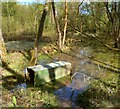
An Old Brick Pit
The Maidenhead Brick and Tile Company operated on this site until the mid 20th century. Practically nothing remains of any kilns or buildings, so for the Industrial Archaeologist there is little to see except for the old quarries which are now a nature reserve. I don't know what that is in the water, a brick making relic or a bit of old junk.
Image: © Des Blenkinsopp Taken: 14 Apr 2014
0.19 miles
7
Warminster Cottages 1934
That's the inscription on the wall tablet above the hedge, with the initials H.E.R. This is quite an urban looking terrace to find in an out of town location. I'm guessing it was built for workers at the nearby Maidenhead Brick and Tile Company, which operated just across the road. Trouble is, Googling "Warminster Cottages" gets you stuff about holiday accommodation in Wiltshire.
Image: © Des Blenkinsopp Taken: 14 Apr 2014
0.19 miles
8
Footpath, Cookham
Crossing a field of barley to the south of Beeching-grove Wood.
Image: © Andrew Smith Taken: 15 Jun 2008
0.20 miles
9
Footpath, Cookham
Crossing a field of barley to the north of Beeching-grove Wood.
Image: © Andrew Smith Taken: 15 Jun 2008
0.24 miles