IMAGES TAKEN NEAR TO
Courthouse Road, MAIDENHEAD, SL6 6HF
Introduction
This page details the photographs taken nearby to Courthouse Road, SL6 6HF by members of the Geograph project.
The Geograph project started in 2005 with the aim of publishing, organising and preserving representative images for every square kilometre of Great Britain, Ireland and the Isle of Man.

There are currently over 7.5m images from over14,400 individuals and you can help contribute to the project by visiting https://www.geograph.org.uk
Image Map
Images are licensed for reuse under creativecommons.org/licenses/by-sa/2.0
Notes
- Clicking on the map will re-center to the selected point.
- The higher the marker number, the further away the image location is from the centre of the postcode.
Image Listing (21 Images Found)
Images are licensed for reuse under creativecommons.org/licenses/by-sa/2.0
Image
Details
Distance
2
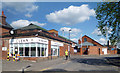
Maidenhead District Laundry
Doing the washing for over 120 years.
Now home to "Clean Linen Services" who have held a Royal Warrant for Laundry Services since 2006. http://www.cleanservices.co.uk/about-clean/
Image: © Des Blenkinsopp
Taken: 14 Apr 2014
0.13 miles
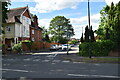

8
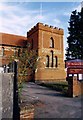
St Peter's Church
A late Victorian brick and tile church. The frontage has been opened up a bit since this view from 10 years ago. Image
Image: © Des Blenkinsopp
Taken: 14 Apr 2014
0.18 miles
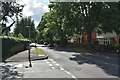
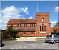
10
St Peter, Furze Platt
Grade 2 listed building erected in 1897.
Image: © Michael FORD
Taken: Unknown
0.18 miles