IMAGES TAKEN NEAR TO
Havelock Crescent, MAIDENHEAD, SL6 5BL
Introduction
This page details the photographs taken nearby to Havelock Crescent, SL6 5BL by members of the Geograph project.
The Geograph project started in 2005 with the aim of publishing, organising and preserving representative images for every square kilometre of Great Britain, Ireland and the Isle of Man.

There are currently over 7.5m images from over14,400 individuals and you can help contribute to the project by visiting https://www.geograph.org.uk
Image Map
Images are licensed for reuse under creativecommons.org/licenses/by-sa/2.0
Notes
- Clicking on the map will re-center to the selected point.
- The higher the marker number, the further away the image location is from the centre of the postcode.
Image Listing (6 Images Found)
Images are licensed for reuse under creativecommons.org/licenses/by-sa/2.0
Image
Details
Distance
1
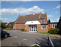
St Mark's Crescent Church
This Methodist Church opened in 1953. http://www.stmarksmaidenhead.org.uk/history.htm
Image: © Des Blenkinsopp
Taken: 14 Apr 2014
0.11 miles
2
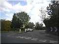
Farm Road at the junction of Pinkneys Road
Image: © David Howard
Taken: 15 May 2016
0.14 miles
3
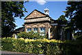
Maidenhead Union, St. Marks Maidenhead
Originally the Cookham Workhouse, it was extended and renamed the Maidenhead Union in 1896. The words "Maidenhead Union" are carved in stone over the Board Room building erected at that time. A few years ago this was once more revealed; apparently the words had been covered over during the War in case this gave a clue to the town's name for invading Germans. The building now forms part of St Mark's Hospital, Maidenhead.
Image: © Stephen Daglish
Taken: 21 Aug 2005
0.23 miles
4
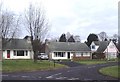
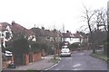
Compton Drive, Maidenhead
Bungalows and chalet-style houses such as these are characteristic of much of this part of Maidenhead. Taken at junction with Arlington Close looking north-east.
Image: © David Kemp
Taken: 2 Jan 2006
0.23 miles
5
Allenby Road, Maidenhead
Taken near the junction with Twynham Road looking south-east. These houses are typical of the pre-War areas of this square.
Image: © David Kemp
Taken: 2 Jan 2006
0.23 miles
6
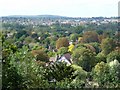
View From South end of Cliveden Woods across to Knowl Hill
Image: © Kevin White
Taken: 22 Sep 2009
0.25 miles