IMAGES TAKEN NEAR TO
Allenby Road, MAIDENHEAD, SL6 5BE
Introduction
This page details the photographs taken nearby to Allenby Road, SL6 5BE by members of the Geograph project.
The Geograph project started in 2005 with the aim of publishing, organising and preserving representative images for every square kilometre of Great Britain, Ireland and the Isle of Man.

There are currently over 7.5m images from over14,400 individuals and you can help contribute to the project by visiting https://www.geograph.org.uk
Image Map
Images are licensed for reuse under creativecommons.org/licenses/by-sa/2.0
Notes
- Clicking on the map will re-center to the selected point.
- The higher the marker number, the further away the image location is from the centre of the postcode.
Image Listing (3 Images Found)
Images are licensed for reuse under creativecommons.org/licenses/by-sa/2.0
Image
Details
Distance
1
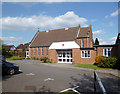
St Mark's Crescent Church
This Methodist Church opened in 1953. http://www.stmarksmaidenhead.org.uk/history.htm
Image: © Des Blenkinsopp
Taken: 14 Apr 2014
0.13 miles
2
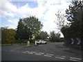
Farm Road at the junction of Pinkneys Road
Image: © David Howard
Taken: 15 May 2016
0.15 miles
3
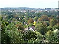
View From South end of Cliveden Woods across to Knowl Hill
Image: © Kevin White
Taken: 22 Sep 2009
0.21 miles