IMAGES TAKEN NEAR TO
Highway Road, MAIDENHEAD, SL6 5AE
Introduction
This page details the photographs taken nearby to Highway Road, SL6 5AE by members of the Geograph project.
The Geograph project started in 2005 with the aim of publishing, organising and preserving representative images for every square kilometre of Great Britain, Ireland and the Isle of Man.

There are currently over 7.5m images from over14,400 individuals and you can help contribute to the project by visiting https://www.geograph.org.uk
Image Map
Images are licensed for reuse under creativecommons.org/licenses/by-sa/2.0
Notes
- Clicking on the map will re-center to the selected point.
- The higher the marker number, the further away the image location is from the centre of the postcode.
Image Listing (7 Images Found)
Images are licensed for reuse under creativecommons.org/licenses/by-sa/2.0
Image
Details
Distance
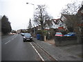
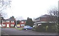
2
Highway Post Office
On the corner of Highway Road and Highway Avenue.
Image: © Des Blenkinsopp
Taken: 14 Apr 2014
0.06 miles
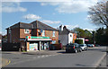
3
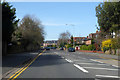
A4 Bath Road, Maidenhead
Heading west out of town.
Image: © Robin Webster
Taken: 22 Mar 2020
0.07 miles
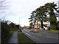
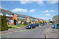
6
Silvertrees Drive, Maidenhead
Detached family houses such as these are to be found not only in the Altwood area of the town (where this shot was taken) but all over Maidenhead.
Image: © David Kemp
Taken: 2 Jan 2006
0.22 miles
7
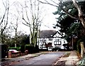
Altwood , Maidenhead
Altwood Close (which isn't a close at all!) pictured here is a bosky road of large detached houses typical of this part of Maidenhead.
Image: © David Kemp
Taken: 2 Jan 2006
0.22 miles