IMAGES TAKEN NEAR TO
Smewins Road, MAIDENHEAD, SL6 3SR
Introduction
This page details the photographs taken nearby to Smewins Road, SL6 3SR by members of the Geograph project.
The Geograph project started in 2005 with the aim of publishing, organising and preserving representative images for every square kilometre of Great Britain, Ireland and the Isle of Man.

There are currently over 7.5m images from over14,400 individuals and you can help contribute to the project by visiting https://www.geograph.org.uk
Image Map
Images are licensed for reuse under creativecommons.org/licenses/by-sa/2.0
Notes
- Clicking on the map will re-center to the selected point.
- The higher the marker number, the further away the image location is from the centre of the postcode.
Image Listing (4 Images Found)
Images are licensed for reuse under creativecommons.org/licenses/by-sa/2.0
Image
Details
Distance
1
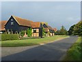
Barns at Smewins Farm, Shottesbrooke
On the White Waltham to Beenham's Heath road. The nearest barn has now been converted into a house.
Image: © Andrew Smith
Taken: 23 Sep 2007
0.21 miles
2
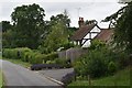
Cottage on Smewins Road, Shottesbrooke
The cottage dates back to the late 16th Century and is a Grade II Listed Building.
Image: © Simon Mortimer
Taken: 4 Jul 2020
0.21 miles
3
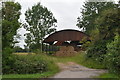
Dutch barn on Smewins Road, Shottesbrooke
Image: © Simon Mortimer
Taken: 4 Jul 2020
0.22 miles